IMAGES TAKEN NEAR TO
Church Hill, NOTTINGHAM, NG16 2HY
Introduction
This page details the photographs taken nearby to Church Hill, NG16 2HY by members of the Geograph project.
The Geograph project started in 2005 with the aim of publishing, organising and preserving representative images for every square kilometre of Great Britain, Ireland and the Isle of Man.

There are currently over 7.5m images from over14,400 individuals and you can help contribute to the project by visiting https://www.geograph.org.uk
Image Map
Images are licensed for reuse under creativecommons.org/licenses/by-sa/2.0
Notes
- Clicking on the map will re-center to the selected point.
- The higher the marker number, the further away the image location is from the centre of the postcode.
Image Listing (55 Images Found)
Images are licensed for reuse under creativecommons.org/licenses/by-sa/2.0
Image
Details
Distance
1
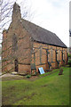
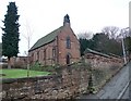
Kimberley Church
Holy Trinity Church on Church Hill was consecrated in 1847 at a time when the population of the area was rapidly expanding. Kimberley, although an ancient settlement mentioned in the Domesday Book (as Chinemarelie), was a part of the parish of Greasley and the original intention was that the new building should act as a chapel of ease to Greasley Church. Kimberley became a parish in 1851, albeit with a curate in charge and an arrangement under which ecclesiastical fees were retained by the vicar of Greasley until the end of his incumbency, which occurred in 1866. More recently, the church underwent a major restoration in 1937.
Image: © Stephen McKay
Taken: 11 Mar 2018
0.02 miles
2
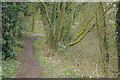
Great Northern Railway Path
At one time Kimberley had two railways. The former Great Northern line between Nottingham and Derby outlasted the old Midland route but was in the end a casualty of the Beeching era, closing to passengers in 1964 and completely four years later. Here the old trackbed has been converted into a path and access is available from Church Hill.
Image: © Stephen McKay
Taken: 11 Mar 2018
0.03 miles
3
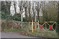
Great Northern Railway Path
At one time Kimberley had two railways. The former Great Northern line between Nottingham and Derby outlasted the old Midland route but was in the end a casualty of the Beeching era, closing to passengers in 1964 and completely four years later. Here the old trackbed has been converted into a path and access is available from Church Hill. The British Transport Commission style station sign advertises the path's presence.
Image: © Stephen McKay
Taken: 11 Mar 2018
0.03 miles
5
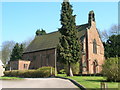
Church of the Holy Trinity, Kimberley
Parish church built in 1847
Image: © Tim Heaton
Taken: 28 Dec 2008
0.04 miles
6
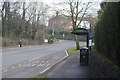
Eastwood Road, Kimberley
This was once the A610, the main road from Nottingham to Heanor - a tedious drag for motorists passing through a series of towns of which Kimberley was one. The by-pass changed all that and this road is now unclassified. From 1913 electric trams used this route, running between Nottingham and Ripley, until the system was replaced by trolleybuses in 1933. The trolleybus service ceased in 1953 but frequent Trentbarton buses still follow the old route.
Image: © Stephen McKay
Taken: 11 Mar 2018
0.06 miles
7
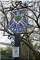
Kimberley
The town sign stands opposite the site of the former Hardys & Hansons Kimberley Brewery which ceased brewing in 2006. For many people in the East Midlands Kimberley will forever be associated with its products and a beer cask is one of the symbols on the sign. Below a notice tells us we are now in a 'place of public protection' which is not really reassuring. It refers to restrictions on the drinking of alcohol in public.
Image: © Stephen McKay
Taken: 11 Mar 2018
0.06 miles
8
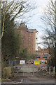
Kimberley Brewery - undergoing redevelopment
A brewery was founded here in Kimberley in 1832 and was subsequently bought by the Hardy family in 1857. In 1930 the business merged with local rivals Hanson's to become Hardys and Hansons - a name that became familiar across the East Midlands, especially around the Nottinghamshire/Derbyshire border where the company owned many pubs. In 2006 it was sold to Suffolk brewer Greene King who declared at the time 'we have long admired (Hardys and Hansons) for its high quality estate, strong management team, dedicated staff and rich heritage'. This did not stop them closing the Kimberley brewery later the same year and moving production to Bury St Edmunds. Nottingham drinkers would say that the beer brewed by Greene King was never quite the same. The old brewery was simply abandoned with much of its equipment left in place, although the site was sold in 2010 to a development company. Redevelopment is now finally happening, converting the site to residential use and happily some of the old buildings will be incorporated into the plan.
Image: © Stephen McKay
Taken: 11 Mar 2018
0.09 miles
9
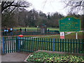
Hall Om Wong 'Open Space', Kimberley
Hall om Wong apparently being Old English for "(Mr) Hall's home piece of land". Part of the 'open space' (why not call it a 'park'?) is a Nature Reserve.
Image: © Tim Heaton
Taken: 28 Dec 2008
0.10 miles
10
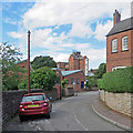
Kimberley: Station Road and a view of the brewery
It's hard to forgive Greene King for acquiring and then closing Hardy & Hanson's Kimberley brewery, which brewed one of the finest ales in the country. Parts of the brewery, which is in the Kimberley Conservation Area, are being redeveloped as flats. The tower and the bridge over Hardy Street will be retained.
Mick Garratt's Image] shows brewing still going on in 2006, the year of closure.
Image: © John Sutton
Taken: 8 Sep 2017
0.10 miles