IMAGES TAKEN NEAR TO
Moorgreen, NOTTINGHAM, NG16 2FE
Introduction
This page details the photographs taken nearby to Moorgreen, NG16 2FE by members of the Geograph project.
The Geograph project started in 2005 with the aim of publishing, organising and preserving representative images for every square kilometre of Great Britain, Ireland and the Isle of Man.

There are currently over 7.5m images from over14,400 individuals and you can help contribute to the project by visiting https://www.geograph.org.uk
Image Map
Images are licensed for reuse under creativecommons.org/licenses/by-sa/2.0
Notes
- Clicking on the map will re-center to the selected point.
- The higher the marker number, the further away the image location is from the centre of the postcode.
Image Listing (26 Images Found)
Images are licensed for reuse under creativecommons.org/licenses/by-sa/2.0
Image
Details
Distance
1
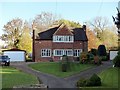
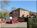
130 & 132 Moorgreen
A pair of estate cottages, by E. W. Godwin for Earl Cowper of Beauvale, dated 1872. The design with its large expanses of window and tile-hanging is remarkably modern for its date. The chimneys were originally considerably taller, probably similar to 53 & 54 Moorgreen http://www.geograph.org.uk/photo/5967326 Listed Grade II.
Image: © Alan Murray-Rust
Taken: 2 Nov 2018
0.04 miles
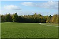
2
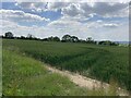
Field of Wheat near Moorgreen
Pictured from an un-gated entrance on New Road.
Image: © Jonathan Clitheroe
Taken: 14 Jun 2022
0.11 miles
3
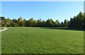
Colliers Wood Local Nature Reserve
Open space at the eastern end of the site, originally storage area for Moorgreen Colliery.
Image: © Alan Murray-Rust
Taken: 2 Nov 2018
0.12 miles
4
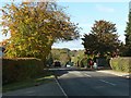
B600 at Moorgreen
The main road from Nottingham to Alfreton, formerly the A613.
Image: © Alan Murray-Rust
Taken: 2 Nov 2018
0.14 miles

6
Moorgreen, former Congregational chapel
Built on land given to the congregation in 1772 by Earl Cowper of Beauvale. Converted to residential use c.2010. Listed Grade II.
Image: © Alan Murray-Rust
Taken: 2 Nov 2018
0.16 miles
7
Colliers Wood Local Nature Reserve
Open space at the eastern end of the site.
Image: © Alan Murray-Rust
Taken: 2 Nov 2018
0.16 miles
8
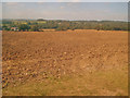
Arable land north of Moorgreen
Looking north-west down a large worked field. Houses at the edge of Moorgreen on the left and High Park Wood on the right. Moorgreen Reservoir is hidden in the woodland at the bottom of the valley.
Image: © Trevor Rickard
Taken: 10 Sep 2009
0.18 miles
9
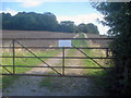
Track north of Moorgreen
Leading east off New Road and up the hill to the small wood at the top. A new communications mast on the right. The sign reads 'Privete Keep Out' and someone has made an effort to change the 'e' to an 'a'.
Image: © Trevor Rickard
Taken: 10 Sep 2009
0.20 miles
10
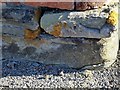
Bench mark, The Horse and Groom, Moorgreen
Difficult to spot in the shadow with the sun very bright. See http://www.geograph.org.uk/photo/5968923 for location.
Image: © Alan Murray-Rust
Taken: 2 Nov 2018
0.21 miles