IMAGES TAKEN NEAR TO
Cloverlands Drive, NOTTINGHAM, NG16 1JJ
Introduction
This page details the photographs taken nearby to Cloverlands Drive, NG16 1JJ by members of the Geograph project.
The Geograph project started in 2005 with the aim of publishing, organising and preserving representative images for every square kilometre of Great Britain, Ireland and the Isle of Man.

There are currently over 7.5m images from over14,400 individuals and you can help contribute to the project by visiting https://www.geograph.org.uk
Image Map
Images are licensed for reuse under creativecommons.org/licenses/by-sa/2.0
Notes
- Clicking on the map will re-center to the selected point.
- The higher the marker number, the further away the image location is from the centre of the postcode.
Image Listing (14 Images Found)
Images are licensed for reuse under creativecommons.org/licenses/by-sa/2.0
Image
Details
Distance
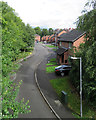
2
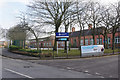
Kimberley School
Kimberley School on Newdigate Street is a secondary school with a sixth form and has academy status. It was original established in 1946.
Image: © Stephen McKay
Taken: 11 Mar 2018
0.10 miles
3
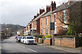
Newdigate Street, Kimberley
Looking down Newdigate Street towards Kimberley's town centre.
Image: © Stephen McKay
Taken: 11 Mar 2018
0.15 miles
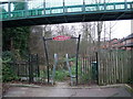
4
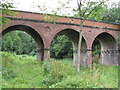
Kimberley Bridge - Midland Railway Bridge 13
This is a footbridge over what used to be the Midland railway. The view is taken with the railway heading towards Watnall and Basford. Behind the camera is the old Midland railway Kimberley station.
Image: © Neil Robinson
Taken: 23 Jul 2010
0.16 miles
5
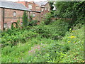
Kimberley: once the goods yard
This street is The Sidings, built on where the goods yard of Kimberley East station once was. A large wooden goods shed survived for a number of years after the Nottingham Victoria to Derby Friargate line closed (to passengers on 7 September 1964 and to goods on 2 November of that year). The line was built by the Great Northern Railway in the 1870s, chiefly to serve the Nottinghamshire and Derbyshire collieries. The view is from the footbridge (now renewed) which crossed the railway.
Image: © John Sutton
Taken: 8 Sep 2017
0.20 miles
6
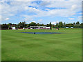
Kimberley Institute Cricket Ground
The square was covered ahead of a match the following day. The mowing patterns give an idea of how steeply the outfield slopes down from the pavilion - the most distinctive feature of the ground. Kimberley Institute is one of the most successful clubs in the Nottinghamshire Premier League.
Image: © John Sutton
Taken: 8 Sep 2017
0.21 miles
7
Great Northern Railway Path
A short path following the former route of the Great Northern Railway. (Not to be confused with the Great Northern Railway Trail - a Sustrans project further north). The flyover pedestrian bridge connects residential areas on Edgwood Road and Newdigate Street.
Image: © Tim Heaton
Taken: 29 Dec 2008
0.21 miles
8
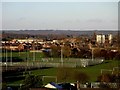
Looking towards Watnall from Kimberley cemetery
This telephoto shot looks over the playing fields of Kimberley School (comprehensive) to the bakery in Watnall, the long building with, on the right, its silos. Further beyond, just visible above the horizon, can be seen the five recently erected (September 2010) turbines of the Lindhurst wind farm, between Mansfield and Blidworth, about 10 miles away as the crow flies. See Image
Image: © Lynne Kirton
Taken: 13 Nov 2010
0.22 miles
9
Great Northern Railway Kimberley Station
This is one of two stations that Kimberley had. The other station was owned by the Midland railway and is close by.
Image: © Neil Robinson
Taken: 23 Jul 2010
0.22 miles
10
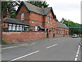
Midland Railway route entering Kimberley
In the background of the image is part of the disused Hardys and Hansons brewery. The remains of a platform is just visible. There is also a bridge that goes over the old railway line that carries a road (Hardy Street). The other side of the bridge is the Midland railway Kimberley station.
Image: © Neil Robinson
Taken: 23 Jul 2010
0.23 miles