IMAGES TAKEN NEAR TO
Common Lane, NOTTINGHAM, NG16 1HD
Introduction
This page details the photographs taken nearby to Common Lane, NG16 1HD by members of the Geograph project.
The Geograph project started in 2005 with the aim of publishing, organising and preserving representative images for every square kilometre of Great Britain, Ireland and the Isle of Man.

There are currently over 7.5m images from over14,400 individuals and you can help contribute to the project by visiting https://www.geograph.org.uk
Image Map
Images are licensed for reuse under creativecommons.org/licenses/by-sa/2.0
Notes
- Clicking on the map will re-center to the selected point.
- The higher the marker number, the further away the image location is from the centre of the postcode.
Image Listing (7 Images Found)
Images are licensed for reuse under creativecommons.org/licenses/by-sa/2.0
Image
Details
Distance
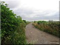
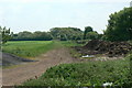
3
Track towards Watnall
This is the access track to Common Farm, also a public footpath. At one time it was also followed by the colliery railway from Watnall Colliery. This provided a separate link to the Great Northern Railway at Watnall, and also to the colliery's own landsale wharf on the site now occupied by the industrial premises visible in the distance.
Image: © Alan Murray-Rust
Taken: 21 May 2010
0.16 miles
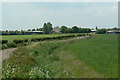
6
Line of old railway
This was the former Midland Railway goods branch which served a number of local collieries.
Image: © Alan Murray-Rust
Taken: 21 May 2010
0.20 miles
7
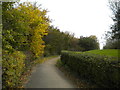
Bridleway off Main Road, Watnall
Climbing to meet the formation of the former Great Northern railway line from Nottingham to Derby.
Image: © Richard Vince
Taken: 28 Oct 2017
0.25 miles