IMAGES TAKEN NEAR TO
Victoria Gardens, NOTTINGHAM, NG16 1GZ
Introduction
This page details the photographs taken nearby to Victoria Gardens, NG16 1GZ by members of the Geograph project.
The Geograph project started in 2005 with the aim of publishing, organising and preserving representative images for every square kilometre of Great Britain, Ireland and the Isle of Man.

There are currently over 7.5m images from over14,400 individuals and you can help contribute to the project by visiting https://www.geograph.org.uk
Image Map
Images are licensed for reuse under creativecommons.org/licenses/by-sa/2.0
Notes
- Clicking on the map will re-center to the selected point.
- The higher the marker number, the further away the image location is from the centre of the postcode.
Image Listing (36 Images Found)
Images are licensed for reuse under creativecommons.org/licenses/by-sa/2.0
Image
Details
Distance
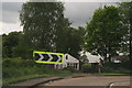
1
Watnall village boundary sign
The aircraft on the sign (a Spitfire?) is a reference to Watnall being the location of the RAF fighter command for the Midlands in WWII.
Image: © Graham Hogg
Taken: 12 May 2015
0.06 miles
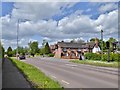
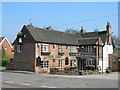
2
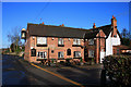
The Queens Head
Watnall. On the B600 north of Nutall.
Image: © David Lally
Taken: 6 Dec 2008
0.07 miles
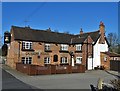
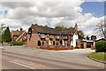
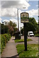
6
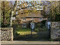
Stone Cottage, Watnall
Mid-18th century stone-built cottage, Listed Grade II.
Image: © Alan Murray-Rust
Taken: 12 Nov 2018
0.07 miles
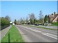
7
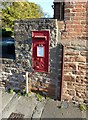
Postbox at the Queens Head, Watnall
Standard GVIR wallbox, ref NG16 119. See https://www.geograph.org.uk/photo/1830548 for location.
Image: © Alan Murray-Rust
Taken: 2 Nov 2018
0.07 miles