IMAGES TAKEN NEAR TO
Oak Drive, NOTTINGHAM, NG16 1FJ
Introduction
This page details the photographs taken nearby to Oak Drive, NG16 1FJ by members of the Geograph project.
The Geograph project started in 2005 with the aim of publishing, organising and preserving representative images for every square kilometre of Great Britain, Ireland and the Isle of Man.

There are currently over 7.5m images from over14,400 individuals and you can help contribute to the project by visiting https://www.geograph.org.uk
Image Map
Images are licensed for reuse under creativecommons.org/licenses/by-sa/2.0
Notes
- Clicking on the map will re-center to the selected point.
- The higher the marker number, the further away the image location is from the centre of the postcode.
Image Listing (9 Images Found)
Images are licensed for reuse under creativecommons.org/licenses/by-sa/2.0
Image
Details
Distance
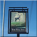
2
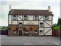
The Stag Inn
Not looking too different from 15 years ago Image
Image: © David Lally
Taken: 1 Dec 2020
0.17 miles
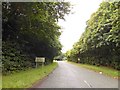
6
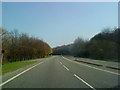
Field near Swingate
The field terminates below the embankment beside the A610, which here forms the Nuthall-Kimberley-Eastwood bypass. Beyond the road is part of Nuthall, and in the distance the hills of north Nottinghamshire.
Image: © Lynne Kirton
Taken: 13 Nov 2010
0.22 miles
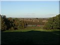
7
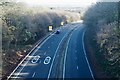
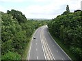
The A610
From the Knowle Hill footbridge. looking east.
Image: © David Lally
Taken: 1 Dec 2020
0.23 miles