IMAGES TAKEN NEAR TO
Clarendon Street, NOTTINGHAM, NG1 5JD
Introduction
This page details the photographs taken nearby to Clarendon Street, NG1 5JD by members of the Geograph project.
The Geograph project started in 2005 with the aim of publishing, organising and preserving representative images for every square kilometre of Great Britain, Ireland and the Isle of Man.

There are currently over 7.5m images from over14,400 individuals and you can help contribute to the project by visiting https://www.geograph.org.uk
Image Map
Images are licensed for reuse under creativecommons.org/licenses/by-sa/2.0
Notes
- Clicking on the map will re-center to the selected point.
- The higher the marker number, the further away the image location is from the centre of the postcode.
Image Listing (524 Images Found)
Images are licensed for reuse under creativecommons.org/licenses/by-sa/2.0
Image
Details
Distance
1

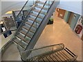
Djanogly International Centre interior, Nottingham Trent University
Image: © Bryn Holmes
Taken: 13 Nov 2018
0.02 miles
2
Djanogly International Centre interior, Nottingham Trent University
Image: © Bryn Holmes
Taken: 13 Nov 2018
0.02 miles
3
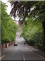
Nottingham - NG1 (Arboretum Area)
The Waverley Street/Peel Street/Clarendon Street crossroads as seen from Clarendon Street. A section of the General Cemetery boundary wall is visible on the left and on the horizon, through the trees, a glimpse of the former Women's Hospital buildings (now apartments) can be caught.
Image: © David Hallam-Jones
Taken: 20 May 2012
0.02 miles
4
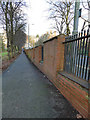
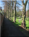
Perimeter path, Nottingham General Cemetery
The road on the other side of the wall is Clarendon Street.
Image: © Stephen Craven
Taken: 18 Jan 2020
0.02 miles
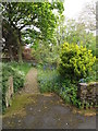
5
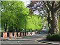
Clarendon Street on a spring morning
The area between Parliament Street and Forest Road was the first of the inner suburbs to be developed after the 1845 Enclosure Act. It includes formerly grand houses and two green spaces, the General Cemetery, whose wall is on the left, and The Arboretum, which is directly ahead on the other side of Waverley Street but not visible through the new spring growth.
Image: © John Sutton
Taken: 16 Apr 2011
0.03 miles
6
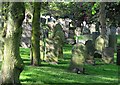
Nottingham General Cemetery: morning shadows and a line of trees
Clarendon Street is on the other side of the wall.
Image: © John Sutton
Taken: 3 May 2016
0.03 miles
7
Nottingham General Cemetery in Spring
Seen over the railings from Clarendon Street. The cemetery was part of the expansion of Nottingham after the Enclosure Act of 1845.
Image: © John Sutton
Taken: 16 Apr 2011
0.03 miles
8
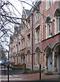
Nottingham - Terrace Royal
At the northern end of Clarendon Street. Now part of Nottingham Trent University. Please see John Sutton's Image for an alternative view and more information on this terrace.
Image: © Dave Bevis
Taken: 25 Feb 2013
0.04 miles
9
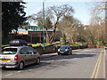
Nottingham - NG1
A view of the Talbot Street end of Clarendon Street showing the descent towards a section of the boundary wall & railings surrounding the distant General Cemetery. The Nottingham Meeting House of the Society of Friends (or Quakers) is seen on the left.
Image: © David Hallam-Jones
Taken: 25 Mar 2012
0.04 miles
10
Nottingham - NG1 (City Centre)
A partial view of the combined garden/burial ground of the Quaker Meeting House on Clarendon Street taken from near to the main Meeting House door. Beyond the wall in the distance is part of the General Cemetery.
Image: © David Hallam-Jones
Taken: 20 May 2012
0.04 miles