IMAGES TAKEN NEAR TO
Talbot Street, NOTTINGHAM, NG1 5EN
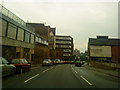
Introduction
This page details the photographs taken nearby to Talbot Street, NG1 5EN by members of the Geograph project.
The Geograph project started in 2005 with the aim of publishing, organising and preserving representative images for every square kilometre of Great Britain, Ireland and the Isle of Man.

There are currently over 7.5m images from over14,400 individuals and you can help contribute to the project by visiting https://www.geograph.org.uk
Image Map
Images are licensed for reuse under creativecommons.org/licenses/by-sa/2.0
Notes
- Clicking on the map will re-center to the selected point.
- The higher the marker number, the further away the image location is from the centre of the postcode.
Image Listing (673 Images Found)
Images are licensed for reuse under creativecommons.org/licenses/by-sa/2.0
Image
Details
Distance
1
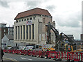
Talbot House, Talbot Street, Nottingham
Art Deco by Dawson & Lambert, 1937, for Sir Julien Cahn. Originally offices, garaging and a private flat.
It has since been converted to student accommodation, in the process of which it has been mangled by the removal of the roof and attic storey.
The neighbouring site was being cleared for student accommodation too, Nova.
Image: © Stephen Richards
Taken: 25 Jun 2015
0.03 miles
2
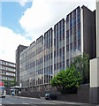
Wollaton. House, Wollaton Street, Nottingham
Rather tired-looking 1970s curtain-walled office block.
Possibly to be demolished in place of student accommodation, the British economy's big growth area.
Image: © Stephen Richards
Taken: 19 Jun 2012
0.04 miles
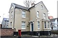
3
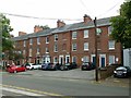
10 ? 30 Clarendon Street, Nottingham
Early Victorian terrace, c.1840, now converted to offices; Listed Grade II except that no.20 is excluded.
Image: © Alan Murray-Rust
Taken: 26 Jul 2019
0.04 miles
4
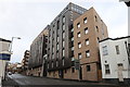
Nova, Nottingham
Student accommodation for 437 persons completed in 2017 at a cost of £20m.
Image: © Andrew Abbott
Taken: 11 Feb 2018
0.05 miles
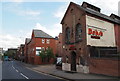
6
60 Talbot Street, Nottingham
Just off Russell Place.
Image: © Andrew Abbott
Taken: 11 Feb 2018
0.05 miles
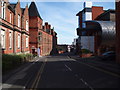
7
Nottingham - NG1 (Wollaton St)
Part of the middle section of Wollaton Street looking towards Tollhouse Hill.
Image: © David Hallam-Jones
Taken: 10 Jun 2012
0.06 miles
8
Nottingham - NG1 (Derby/Wollaton Rds)
Derby Road looking down the length of Derby Street, from Wollaton Street.
Image: © David Hallam-Jones
Taken: 10 Jun 2012
0.06 miles
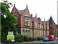
9
Nottingham - NG1
New College Nottingham’s 6th Form College on the right-hand side moved to Chaucer Street in 2001. The £6.3m building with its horizontally positioned ‘tin can roof' was designed by Ellis Williams Architects. The school began life as the Unitarian Day Charity School in the Lace Market area, later changing its name to High Pavement Grammar School. During 1895-1955 the school was situated in Stanley Rd in Forest Fields until it moved to a site on the Bestwood Estate. In 1975 it became High Pavement 6th Form College and in 1999 it was amalgamated into New College Nottingham. The Clarendon building on the left is divided into two sections, one used by Nottingham Trent University and the other by the Nottingham Women's Centre. This extensive building was built as The Midland Institution for the Blind. It was erected in 1853 to "educate fifty inmates and an unlimited number of non-resident blind persons and to instruct them in basket-making and other trades and callings". Additional workshops were added in 1889.
Image: © David Hallam-Jones
Taken: 25 Mar 2012
0.06 miles
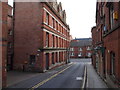
10
Clarendon Chambers, Chaucer Street
Built 1853 for the Royal Midland Institute for the Blind, now operated by the City Council as offices and workshops for small business. Listed Grade II.
Image: © Alan Murray-Rust
Taken: 26 Jul 2019
0.06 miles