IMAGES TAKEN NEAR TO
Hanley Street, NOTTINGHAM, NG1 5BL
Introduction
This page details the photographs taken nearby to Hanley Street, NG1 5BL by members of the Geograph project.
The Geograph project started in 2005 with the aim of publishing, organising and preserving representative images for every square kilometre of Great Britain, Ireland and the Isle of Man.

There are currently over 7.5m images from over14,400 individuals and you can help contribute to the project by visiting https://www.geograph.org.uk
Image Map
Images are licensed for reuse under creativecommons.org/licenses/by-sa/2.0
Notes
- Clicking on the map will re-center to the selected point.
- The higher the marker number, the further away the image location is from the centre of the postcode.
Image Listing (1143 Images Found)
Images are licensed for reuse under creativecommons.org/licenses/by-sa/2.0
Image
Details
Distance
1
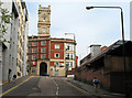
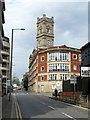
Hanley Street
The picture, taken from Wollaton Street, is dominated by the grand tower of the former Lambert's Factory of 1864 on Talbot Street, now offices. When I was a boy, Hanley Street was the terminus for Nottingham Corporation bus services to Aspley, Broxtowe and Strelley, the ones I caught into town. They came in to town up Alfreton Road, then down Talbot Street, returning up Wollaton Street to Canning Circus. The stops were against the wall on the right, which belonged to the electricity works, long replaced by a multi-storey car park.
Image: © John Sutton
Taken: 19 May 2010
0.02 miles
2
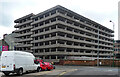
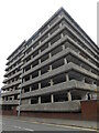
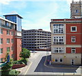
Car park, Talbot Street, Nottingham
Multi-storey with a sculptural quality to it, at a stretch perhaps.
Image: © Stephen Richards
Taken: 25 Jun 2015
0.03 miles
4

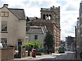
Stanley House, Wollaton Street, Nottingham
The tower and part of the facade collapsed during rebuilding work in the 1990s, but the local Planning Authority rejected an application for demolition and insisted on reconstruction. Listed Grade II.
See http://www.geograph.org.uk/photo/6226546 for location.
Image: © Alan Murray-Rust
Taken: 26 Jul 2019
0.03 miles
5
Talbot Street
The view is dominated by Lambert's Factory, a hosiery works dating from 1864, now offices. The single-decker bus from Wollaton is making its way into town.
Image: © John Sutton
Taken: 11 May 2012
0.04 miles
6
Stanley House, Wollaton Street, Nottingham
Former Lambert lace factory of 1863, Listed Grade II, converted to offices in the late 20th century. Unoccupied at the time this view was taken, with planning consent for conversion to student accommodation. The section on the corner is a late 20th century addition and is not part of the Listing.
Image: © Alan Murray-Rust
Taken: 26 Jul 2019
0.04 miles
7

Stanley House, Wollaton Street, Nottingham
Decorative parapet of the Wollaton Street facade.
See http://www.geograph.org.uk/photo/6226546 for location.
Image: © Alan Murray-Rust
Taken: 26 Jul 2019
0.04 miles
8
Nottingham - NG1 (Talbot St)
Stanley Place, with the Welbeck Hotel on the left, as seen from the top of the steps approaching the entrance to the now-defunct Government Office for the East Midlands. The multi-storey car park in the background is on Talbot Street.
Image: © David Hallam-Jones
Taken: 17 Jun 2012
0.04 miles
9

Stanley House, Talbot Street
Grade II listed. Listing number 1270427. Former bleaching, dyeing and finishing works, now offices. 1863. For John and William Lambert, lace dressers. Factory ranges at the rear demolished 1979. Converted and restored 1991-93. Clock tower rebuilt following collapse.
Image: © Andrew Abbott
Taken: 11 Feb 2018
0.04 miles
10

Nottingham
View from the Crowne Plaza Hotel.
Image: © Peter McDermott
Taken: 18 Jun 2016
0.05 miles