IMAGES TAKEN NEAR TO
Heather Lane, NOTTINGHAM, NG15 9AS
Introduction
This page details the photographs taken nearby to Heather Lane, NG15 9AS by members of the Geograph project.
The Geograph project started in 2005 with the aim of publishing, organising and preserving representative images for every square kilometre of Great Britain, Ireland and the Isle of Man.

There are currently over 7.5m images from over14,400 individuals and you can help contribute to the project by visiting https://www.geograph.org.uk
Image Map
Images are licensed for reuse under creativecommons.org/licenses/by-sa/2.0
Notes
- Clicking on the map will re-center to the selected point.
- The higher the marker number, the further away the image location is from the centre of the postcode.
Image Listing (18 Images Found)
Images are licensed for reuse under creativecommons.org/licenses/by-sa/2.0
Image
Details
Distance
1
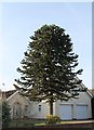
Monkey Puzzle Tree, Chapel Lane, Ravenshead
A fine example.
Image: © J.Hannan-Briggs
Taken: 17 Feb 2013
0.04 miles
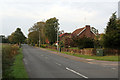
2
Chapel Lane
This marks the eastern boundary of the residential development of Ravenshead. It gets its name from the old Ebenezer Chapel at Fishpool, the forerunner of Ravenshead.
Image: © Alan Murray-Rust
Taken: 23 Oct 2011
0.09 miles
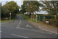
3
Longdale Lane
Looking northwest at the junction with Chapel Lane. Development of Ravenshead as a residential area started in the late 1930s within what had been part of the Newstead Abbey estate.
Image: © Alan Murray-Rust
Taken: 23 Oct 2011
0.09 miles
4
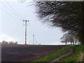
Power lines in a ploughed field beside the Robin Hood Way
Image: © Graham Hogg
Taken: 4 Apr 2016
0.10 miles
5
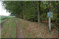
Riders must keep to the bridleway
Pedestrians also presumably, but this is not stated. Bridleway near Blidworth Dale, part of the Robin Hood Way long distance footpath.
Image: © Alan Murray-Rust
Taken: 23 Oct 2011
0.11 miles
6
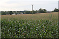
Maize crop near Ravenshead
I was surprised that this crop had not been harvested by late October.
Image: © Alan Murray-Rust
Taken: 23 Oct 2011
0.12 miles
7
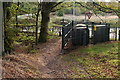
Electrical substation
At the junction of Longdale Lane and Kighill Lane, serving the south-eastern sector of Ravenshead. The Robin Hood Way passes to its side.
Image: © Alan Murray-Rust
Taken: 23 Oct 2011
0.12 miles
9

A fleece-covered early crop
Protecting some baby plants that are beginning to show through the fleece.
Image: © Ian Calderwood
Taken: 24 Feb 2024
0.14 miles
10
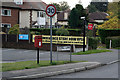
Kighill Lane postbox ref no.NG15 35
E II R lampbox on the corner of Kighill Lane and Longdale Lane.
Image: © Alan Murray-Rust
Taken: 23 Oct 2011
0.15 miles