IMAGES TAKEN NEAR TO
Kenbrook Road, NOTTINGHAM, NG15 8HS
Introduction
This page details the photographs taken nearby to Kenbrook Road, NG15 8HS by members of the Geograph project.
The Geograph project started in 2005 with the aim of publishing, organising and preserving representative images for every square kilometre of Great Britain, Ireland and the Isle of Man.

There are currently over 7.5m images from over14,400 individuals and you can help contribute to the project by visiting https://www.geograph.org.uk
Image Map
Images are licensed for reuse under creativecommons.org/licenses/by-sa/2.0
Notes
- Clicking on the map will re-center to the selected point.
- The higher the marker number, the further away the image location is from the centre of the postcode.
Image Listing (47 Images Found)
Images are licensed for reuse under creativecommons.org/licenses/by-sa/2.0
Image
Details
Distance
1
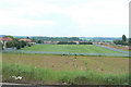
Playing fields
At the back of houses off Papplewick Lane.
Image: © Alan Murray-Rust
Taken: 7 Jun 2010
0.06 miles
2
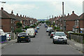
Oakenhall Avenue
A long cul-de-sac off Wigwam Lane surrounded by greenery.
Image: © Alan Murray-Rust
Taken: 7 Jun 2010
0.07 miles
4
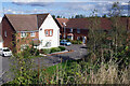
Olympia Way, Hucknall
Looking down from Wigwam Lane, the houses here were built in 2013. They are especially convenient for the town's railway station and tram stop.
Image: © Stephen McKay
Taken: 16 Sep 2022
0.09 miles
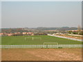
5
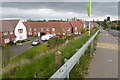
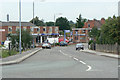
New Estate of houses beside Wigwam Lane
Route 6 of the National Cycle Network goes along here but at this point it's unclear as to whether one should be on the pavement (possibly allocated as a shared cycle path?) or the road.
Although this looks at this point like a major through route to somewhere Wigwam Lane is just for access to industrial units at Butler's Hill and is a no through road for motor vehicles.
Image: © David Lally
Taken: 27 Apr 2017
0.11 miles
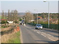
7
Papplewick Lane in Hucknall
Situated at the western edge of this square close to the railway station.
Image: © Jonathan Clitheroe
Taken: 14 Jun 2022
0.12 miles
8
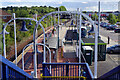
Hucknall Station and Tram Stop
This is a rather complicated scene showing Hucknall's one platform railway station opened in 1993 as a replacement for Hucknall Byron which closed almost 30 years earlier in 1964. To the right of that is the tram stop, a terminus on the NET network, first opened in 2004.
Image: © Stephen McKay
Taken: 16 Sep 2022
0.13 miles
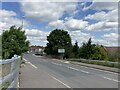
9
Papplewick Lane
The descent from the railway bridge at Hucknall Station. The original alignment before the coming of the railway would have gone straight past the frontage of the building to the left.
Image: © Alan Murray-Rust
Taken: 7 Jun 2010
0.14 miles
10
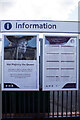
Information and condolences - Hucknall Station
These two posters are on the platform at Hucknall station. The one on the right is a timetable for Robin Hood Line services. The one on the left is more special - a message from East Midlands Railway: 'We send our deepest condolences and sympathies to the Royal Family at this difficult time'.
Image: © Stephen McKay
Taken: 16 Sep 2022
0.14 miles