IMAGES TAKEN NEAR TO
Minerva Grove, NOTTINGHAM, NG15 8GW
Introduction
This page details the photographs taken nearby to Minerva Grove, NG15 8GW by members of the Geograph project.
The Geograph project started in 2005 with the aim of publishing, organising and preserving representative images for every square kilometre of Great Britain, Ireland and the Isle of Man.

There are currently over 7.5m images from over14,400 individuals and you can help contribute to the project by visiting https://www.geograph.org.uk
Image Map
Images are licensed for reuse under creativecommons.org/licenses/by-sa/2.0
Notes
- Clicking on the map will re-center to the selected point.
- The higher the marker number, the further away the image location is from the centre of the postcode.
Image Listing (4 Images Found)
Images are licensed for reuse under creativecommons.org/licenses/by-sa/2.0
Image
Details
Distance
1
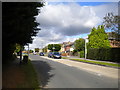
South eastern end of Hayden Lane, Hucknall
Seen from the junction with Papplewick Lane.
Image: © Richard Vince
Taken: 12 Aug 2017
0.14 miles
2
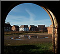
Papplewick, NG15
A cluster of new homes on Falcon Way, on the new Papplewick Green residential estate, Papplewick Lane, as seen from inside one of Grange Farm's derelict barns. Grange Farm is situated at the end of Grange Farm Gardens that empties out onto Moor Road (the B683). It is currently "For Sale" with planning permission for the construction of 18 houses.
Image: © David Hallam-Jones
Taken: 17 Nov 2012
0.17 miles
3
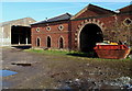
Papplewick, NG15 - Grange Farm
Farm buildings on the Grange Farm site. The farm is for sale for 18 residential units with the main access expected to be via the Papplewick Green residential estate on Papplewick Lane, Hucknall (behind the photographer) rather than via Grange Farm Lane, behind this brick building.
Image: © David Hallam-Jones
Taken: 17 Nov 2012
0.20 miles
4
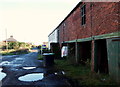
Papplewick, NG15 - Grange Farm
This track connects Grange Farm - currently "For Sale" - and a small number of private homes (Grange Farm Cottages) with Moor Road (the B683) that can be seen in the distance. Behind the photographer and beyond a farm yard area, temporary security fencing has been erected to separate this very dilapidated farm from a housing construction site accessed via Papplewick Lane, Hucknall.
Image: © David Hallam-Jones
Taken: 17 Nov 2012
0.24 miles