IMAGES TAKEN NEAR TO
Moor Road, NOTTINGHAM, NG15 8FR
Introduction
This page details the photographs taken nearby to Moor Road, NG15 8FR by members of the Geograph project.
The Geograph project started in 2005 with the aim of publishing, organising and preserving representative images for every square kilometre of Great Britain, Ireland and the Isle of Man.

There are currently over 7.5m images from over14,400 individuals and you can help contribute to the project by visiting https://www.geograph.org.uk
Image Map
Images are licensed for reuse under creativecommons.org/licenses/by-sa/2.0
Notes
- Clicking on the map will re-center to the selected point.
- The higher the marker number, the further away the image location is from the centre of the postcode.
Image Listing (35 Images Found)
Images are licensed for reuse under creativecommons.org/licenses/by-sa/2.0
Image
Details
Distance
1
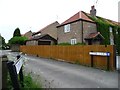
Entrance to Clover Court, Papplewick
New housing development facing Linby Lane, but accessed from Moor Lane.
Image: © Christine Johnstone
Taken: 5 Jun 2013
0.02 miles
2
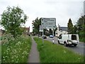
Left for Linby, right for Arnold
Crossroads sign, Moor Lane, Papplewick.
Image: © Christine Johnstone
Taken: 5 Jun 2013
0.03 miles
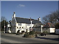
3
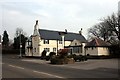
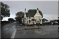
The Griffins Head, Papplewick
Large pub at the crossroads in the village centre
Image: © Graham Hogg
Taken: 31 Mar 2014
0.03 miles
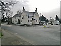
4
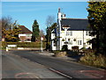
Papplewick, NG15
The Griffin's Head pub is seen here at the crossroads with the B6011, with the majority of Moor Road (the B683 road) behind the photographer. The road stretches back for several miles behind the photographer forming a T junction with the A611 (Nottingham-Hucknall) Road. The pub is Grade II-listed, having been built during the 18-19th century. The Griffin's head symbol may have stemmed from this creature's appearance on the family crest of the Montagu's of Papplewick Hall, one of whom was Charles Montagu the M.P., who died in 1759.
Image: © David Hallam-Jones
Taken: 17 Nov 2012
0.03 miles
6
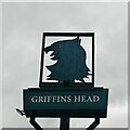
The sign of the Griffins Head
Image: © David Lally
Taken: 28 Jun 2023
0.04 miles
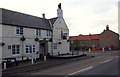
9
Griffins Head, Papplewick
The village pub seen in a sharp rain shower.
Image: © Bill Boaden
Taken: 15 Oct 2022
0.04 miles
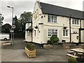
10
Papplewick, NG15
The Griffin's Head pub seen from Forest Lane (part of the B6011). The road continues for several miles behind the photographer until it forms a T junction with the A60 (Nottingham-Mansfield) Road. The pub is Grade II-listed, having been built between the mid 18-19th century. A Griffin's head may have stemmed from this creature's appearance on the family crest of the Montagu's of Papplewick Hall, one of whom was Charles Montagu the M.P., who died in 1759.
Image: © David Hallam-Jones
Taken: 17 Nov 2012
0.05 miles