IMAGES TAKEN NEAR TO
Mansfield Road, NOTTINGHAM, NG15 8FJ
Introduction
This page details the photographs taken nearby to Mansfield Road, NG15 8FJ by members of the Geograph project.
The Geograph project started in 2005 with the aim of publishing, organising and preserving representative images for every square kilometre of Great Britain, Ireland and the Isle of Man.

There are currently over 7.5m images from over14,400 individuals and you can help contribute to the project by visiting https://www.geograph.org.uk
Image Map
Images are licensed for reuse under creativecommons.org/licenses/by-sa/2.0
Notes
- Clicking on the map will re-center to the selected point.
- The higher the marker number, the further away the image location is from the centre of the postcode.
Image Listing (8 Images Found)
Images are licensed for reuse under creativecommons.org/licenses/by-sa/2.0
Image
Details
Distance
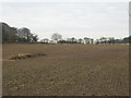
2
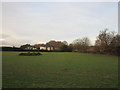
Grass field and houses on Mansfield Road
Image: © Jonathan Thacker
Taken: 7 Dec 2019
0.14 miles
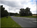
4
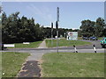
Forest Lane
Junction of the A60 and B6011, which goes to Papplewick and Linby
Image: © Tom Courtney
Taken: 8 Aug 2005
0.17 miles
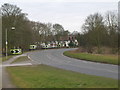
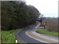
6
A60 Mansfield Road east of Papplewick
Looking towards Mansfield from the junction with the B6011 Forest Lane, hence the multiple lanes visible on the right.
Image: © Richard Vince
Taken: 12 Aug 2017
0.19 miles
7
Forest Lane
The B6011 between the A60 and Papplewick
Image: © Graham Hogg
Taken: 4 Apr 2016
0.21 miles
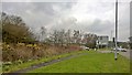
8
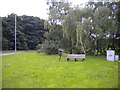
Bench and bin next to Forest Lane east of Papplewick
A less tranquil location than it appears, as the A60 (the main road between Nottingham and Mansfield) is immediately behind the photographer.
Image: © Richard Vince
Taken: 12 Aug 2017
0.21 miles