IMAGES TAKEN NEAR TO
Linby Lane, NOTTINGHAM, NG15 8FB
Introduction
This page details the photographs taken nearby to Linby Lane, NG15 8FB by members of the Geograph project.
The Geograph project started in 2005 with the aim of publishing, organising and preserving representative images for every square kilometre of Great Britain, Ireland and the Isle of Man.

There are currently over 7.5m images from over14,400 individuals and you can help contribute to the project by visiting https://www.geograph.org.uk
Image Map
Images are licensed for reuse under creativecommons.org/licenses/by-sa/2.0
Notes
- Clicking on the map will re-center to the selected point.
- The higher the marker number, the further away the image location is from the centre of the postcode.
Image Listing (39 Images Found)
Images are licensed for reuse under creativecommons.org/licenses/by-sa/2.0
Image
Details
Distance
1
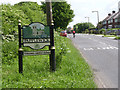
Papplewick village sign on Linby Lane
Papplewick has chosen to have several different designs. This one illustrates the church.
Image: © Alan Murray-Rust
Taken: 1 Jun 2014
0.03 miles
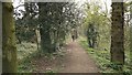
2
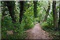
Wooded path near Castle Mill
Part of the Papplewick Trail.
Image: © David Lally
Taken: 27 Oct 2021
0.07 miles
3
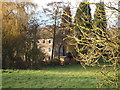
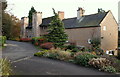
Papplewick, NG15
The south elevation of the former "Top Mill" (a.k.a. Robinson's Mill and Castle Mill, on account of its design) as seen from a field at its rear. The mill was constructed on Linby Lane c.1777 for a Mr George Robinson (a Scot previously known as Robertson). After it ceased to function as a cotton mill, c.1820, it was used as a corn-mill. It was purchased by the Hucknall Torkard Industrial Provident Society in 1919, who sold it in 1952 when it was converted in apartments. Some of the surrounding land and leats are still owned by the Cooperative Society. Sadly, the graves of some of the many pauper children who were brought from the St Marylebone Workhouse to work in this mill and who died 'in service' can be seen in Linby Church graveyard.
Image: © David Hallam-Jones
Taken: 17 Nov 2012
0.08 miles
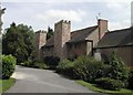
5
Papplewick, NG15
The north elevation of the former "Top Mill" (a.k.a. Robinson's Mill and Castle Mill, on account of its design) as viewed from what is now the driveway of these premises converted into apartments in 1952. The B6011 now runs along the other side of the hedge on the left of this picture although originally this driveway - once the road between Linby and Papplewick - passed almost immediately in front of the mill along the top of a dam that held back the body of water used to drive a mill wheel previously situated to the left. The mill was constructed in 1782 for a Mr George Robinson (a Scot previously known as Robertson), although after it ceased to function as a cotton mill - c.1820 - it was used as a corn-mill. It was purchased by the Hucknall Torkard Industrial Provident Society in 1919 and sold on again later. When water power was no longer required and once the reservoir was no longer necessary the water behind the dam - beyond the hedge - was drained (c.1946). Sadly, the graves of some of the many pauper children who were brought from St Marylebone Workhouse to work in this mill and who died 'in service' can be seen in Linby Church graveyard.
Image: © David Hallam-Jones
Taken: 17 Nov 2012
0.11 miles
6
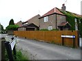
Entrance to Clover Court, Papplewick
New housing development facing Linby Lane, but accessed from Moor Lane.
Image: © Christine Johnstone
Taken: 5 Jun 2013
0.12 miles
8
Left for Linby, right for Arnold
Crossroads sign, Moor Lane, Papplewick.
Image: © Christine Johnstone
Taken: 5 Jun 2013
0.13 miles
9
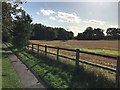
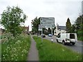
Ploughed Field Adjoining Moor Pond Wood
Also visible here is a path running alongside the B683 road out of Papplewick.
Image: © Jonathan Clitheroe
Taken: 12 Sep 2020
0.13 miles
10
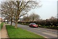
Spring flowers in Papplewick
Brightening the B1683 road to the south of the village
Image: © Graham Hogg
Taken: 31 Mar 2014
0.13 miles