Papplewick, NG15
Introduction
The photograph on this page of Papplewick, NG15 by David Hallam-Jones as part of the Geograph project.
The Geograph project started in 2005 with the aim of publishing, organising and preserving representative images for every square kilometre of Great Britain, Ireland and the Isle of Man.

There are currently over 7.5m images from over 14,400 individuals and you can help contribute to the project by visiting https://www.geograph.org.uk
Papplewick, NG15
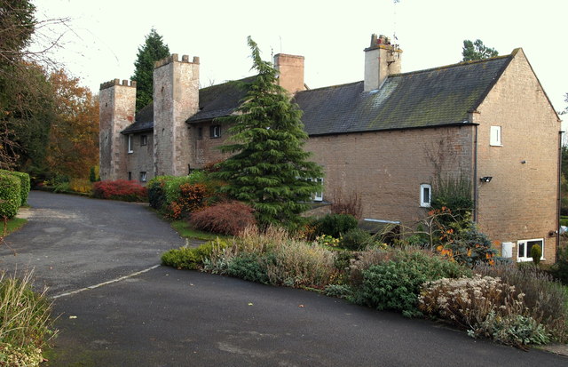
Image: © David Hallam-Jones Taken: 17 Nov 2012
The north elevation of the former "Top Mill" (a.k.a. Robinson's Mill and Castle Mill, on account of its design) as viewed from what is now the driveway of these premises converted into apartments in 1952. The B6011 now runs along the other side of the hedge on the left of this picture although originally this driveway - once the road between Linby and Papplewick - passed almost immediately in front of the mill along the top of a dam that held back the body of water used to drive a mill wheel previously situated to the left. The mill was constructed in 1782 for a Mr George Robinson (a Scot previously known as Robertson), although after it ceased to function as a cotton mill - c.1820 - it was used as a corn-mill. It was purchased by the Hucknall Torkard Industrial Provident Society in 1919 and sold on again later. When water power was no longer required and once the reservoir was no longer necessary the water behind the dam - beyond the hedge - was drained (c.1946). Sadly, the graves of some of the many pauper children who were brought from St Marylebone Workhouse to work in this mill and who died 'in service' can be seen in Linby Church graveyard.
Images are licensed for reuse under creativecommons.org/licenses/by-sa/2.0
Image Location
Latitude
53.053668
Longitude
-1.188513