IMAGES TAKEN NEAR TO
Moor Road, NOTTINGHAM, NG15 8EN
Introduction
This page details the photographs taken nearby to Moor Road, NG15 8EN by members of the Geograph project.
The Geograph project started in 2005 with the aim of publishing, organising and preserving representative images for every square kilometre of Great Britain, Ireland and the Isle of Man.

There are currently over 7.5m images from over14,400 individuals and you can help contribute to the project by visiting https://www.geograph.org.uk
Image Map
Images are licensed for reuse under creativecommons.org/licenses/by-sa/2.0
Notes
- Clicking on the map will re-center to the selected point.
- The higher the marker number, the further away the image location is from the centre of the postcode.
Image Listing (26 Images Found)
Images are licensed for reuse under creativecommons.org/licenses/by-sa/2.0
Image
Details
Distance
1
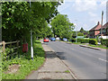
Moor Lane, looking towards Papplewick village
The postbox is shown with more detail here http://www.geograph.org.uk/photo/4014187
Image: © Alan Murray-Rust
Taken: 1 Jun 2014
0.02 miles
2
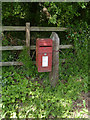
Papplewick Moor Lane postbox ref NG15 31
Standard EIIR lampbox, fixed to a traditional wooden pole.
Image: © Alan Murray-Rust
Taken: 1 Jun 2014
0.06 miles
3
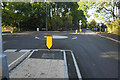
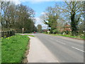
Mini roundabout at the top of Papplewick Lane
The village of Papplewick is another half a kilometre along the road ahead.
Image: © Bill Boaden
Taken: 15 Oct 2022
0.07 miles
4
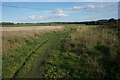
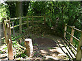
Path onto Papplewick Moor
Part of the Robin Hood Way heading towards Burntstump Hill.
Image: © Bill Boaden
Taken: 15 Oct 2022
0.08 miles
5
Woodland path near Warp Mill, Papplewick
Image: © Richard Vince
Taken: 12 Aug 2017
0.09 miles
6
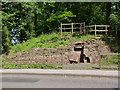
Moor Pond dam and sluice
Part of the water control system for the mills along the River Leen. Excavated and conserved in 2007.
Image: © Alan Murray-Rust
Taken: 1 Jun 2014
0.09 miles
7
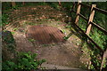
The top of Moor Pond sluice
The grille covers a 4 metre deep shaft which held the sluice.
Image: © Alan Murray-Rust
Taken: 1 Jun 2014
0.09 miles
8
Sluice and shaft at Moor Pond Wood, Papplewick
See also photo Image
The sluice is a feature of a mill created by George Robinson, an 18th-19th century businessman. Hailing from Scotland, he eventually settled in the Bulwell area in 1738. He was in the cotton industry around the time when cotton was starting to supersede the linen industry.
Along the valley of the River Leen in the Linby and Papplewick parishes he created several mills and houses for the workers.
Since the mills closed in the 1820s all the embankments in the project area have been planted with oak and ash woodland.
Behind the sluice is Moor Pond. The sluice was discovered (among the trees) and excavated in 2007. It controlled the amount of water going into Moor Pond from the moor (which is the name given to level ground on the other side of the road).
Below the grill is a brick-lined shaft 4m deep. Looking down, you can see the slot that contained the sluice. The shaft is an unusual oval shape.
More info.: http://moorpond.papplewick.org/index.html ; http://moorpond.papplewick.org/map_alt.html ;
See: http://moorpond.papplewick.org/documents/audio-script.pdf
Image: © Chris
Taken: 1 Sep 2012
0.09 miles
10
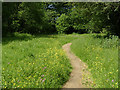
Papplewick Trail
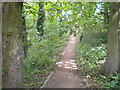
The trail is based on the water-driven industries along the Leen Valley. This short length of path through a spring meadow cuts the corner of Moor Lane and Papplewick Lane.
Image: © Alan Murray-Rust
Taken: 1 Jun 2014
0.10 miles