IMAGES TAKEN NEAR TO
Barbara Square, NOTTINGHAM, NG15 8AQ
Introduction
This page details the photographs taken nearby to Barbara Square, NG15 8AQ by members of the Geograph project.
The Geograph project started in 2005 with the aim of publishing, organising and preserving representative images for every square kilometre of Great Britain, Ireland and the Isle of Man.

There are currently over 7.5m images from over14,400 individuals and you can help contribute to the project by visiting https://www.geograph.org.uk
Image Map
Images are licensed for reuse under creativecommons.org/licenses/by-sa/2.0
Notes
- Clicking on the map will re-center to the selected point.
- The higher the marker number, the further away the image location is from the centre of the postcode.
Image Listing (12 Images Found)
Images are licensed for reuse under creativecommons.org/licenses/by-sa/2.0
Image
Details
Distance
1
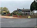
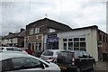
Vaadi bar and restaurant
Until just a few months ago this was "Bella Mia" Image Before that it was The Malt Shovel public house. Unfortunately the site has no pictures from that time.
Image: © David Lally
Taken: 3 Apr 2024
0.06 miles
2
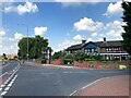
Annesley Road in Wighay
Pictured at its junction with Barbara Square with the Bella Mia bar and restaurant located beyond.
Image: © Jonathan Clitheroe
Taken: 9 Sep 2023
0.06 miles
4
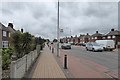
Annesley Road
Looking north away from Hucknall
Image: © David Lally
Taken: 27 Apr 2017
0.19 miles
6
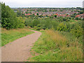
Path to Hucknall
Heading south off the hill towards housing at Hucknall. The whole area was the waste tip from the Linby Colliery which closed in 1988. The country park was created by Nottingham Council in 1994 and is now reasonably mature.
Image: © Trevor Rickard
Taken: 18 Sep 2010
0.22 miles
7
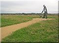
Statue at the top of The Ranges
Looking east at the top of The Ranges, formerly the waste tip from the Linby Colliery, which closed in 1988. The country park was landscaped by Nottingham Council in 1994. The twelve-foot-high statue by Lewis Morgan cost £13,000 and was erected in 2007, funded from the Building Better Communities scheme. A consultation event at Hucknall Library led to local residents choosing the man and dog as their favourite from three designs. The design was partly inspired by the poem Byron wrote as a tribute to his dog, Boatswain - see Image
Lewis Morgan - http://www.lewismorgansculpture.co.uk/public_art.html
Image: © Trevor Rickard
Taken: 18 Sep 2010
0.23 miles
8
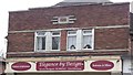
Art Deco detail
On an Annesley Road shop front. From around 1938 I'd say.
Image: © David Lally
Taken: 27 Apr 2017
0.23 miles
9
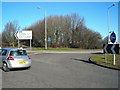
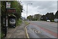
Roundabout and trig point on Annesley Road, Wighay
You can just about see the trig point in this shot - it's that pale smudge in the middle of the clump of trees, just to the right of the blue sign. The track leads to Top Wighay Farm.
Image: © Antony Dixon
Taken: 19 Feb 2012
0.23 miles
10
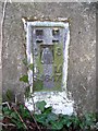
Trig point S4647
Close-up of the trig point at Wighay, for those who are keen on such things.
Image: © Antony Dixon
Taken: 19 Feb 2012
0.23 miles