IMAGES TAKEN NEAR TO
Baker Brook Close, NOTTINGHAM, NG15 7WE
Introduction
This page details the photographs taken nearby to Baker Brook Close, NG15 7WE by members of the Geograph project.
The Geograph project started in 2005 with the aim of publishing, organising and preserving representative images for every square kilometre of Great Britain, Ireland and the Isle of Man.

There are currently over 7.5m images from over14,400 individuals and you can help contribute to the project by visiting https://www.geograph.org.uk
Image Map
Images are licensed for reuse under creativecommons.org/licenses/by-sa/2.0
Notes
- Clicking on the map will re-center to the selected point.
- The higher the marker number, the further away the image location is from the centre of the postcode.
Image Listing (33 Images Found)
Images are licensed for reuse under creativecommons.org/licenses/by-sa/2.0
Image
Details
Distance
1
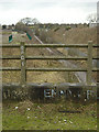
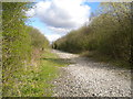
Footpath to Hucknall
A long-standing right of way between Bestwood Village and Hucknall, seen from the railway bridge of the disused railway line to Calverton Colliery
Image: © Alan Murray-Rust
Taken: 13 Jan 2008
0.02 miles
2
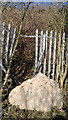
Bowled over by a bold boulder!
Must have rolled down hill from top of tip, and hasn't done the fence a lot of good, but had stopped before crossing our path.
Image: © Chris Morgan
Taken: 10 Mar 2014
0.05 miles
3
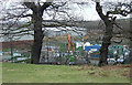
Hucknall recycling centre
Alongside an industrial estate built on the site of a former brickworks
Image: © Alan Murray-Rust
Taken: 13 Jan 2008
0.07 miles
4
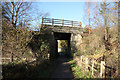
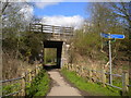
Bestwood Footpath bridge
Footpath under an old colliery line
Image: © Richard Croft
Taken: 25 Nov 2011
0.09 miles
5
Railway trackbed north west of Bestwood Village
This is the trackbed of the branch line from Bestwood Park Junction to Calverton Colliery (open 1952 to 1999). After the closure of the colliery, the railway line was retained as a test track for civil engineering machines, but was later lifted.
Image: © Richard Vince
Taken: 2 Apr 2017
0.10 miles
6
Former railway bridge north west of Bestwood Village
Built to carry the railway line to Calverton colliery across a public footpath to Hucknall.
Image: © Richard Vince
Taken: 2 Apr 2017
0.10 miles
7
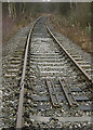
The railway to Calverton Colliery
Although this line served only Calverton Colliery, it was built as double track and only singled in relatively recent times. Calverton was one of the later Nottinghamshire collieries to close and was a relatively modern pit. It was modernised to operate with Merry-go-round trains for the Trent Valley power stations and therefore was built to heavy standards, including as can be seen here, lengths of continuously welded rail.
Image: © Alan Murray-Rust
Taken: 13 Jan 2008
0.10 miles
8
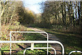
Route 6
North on NCN route 6 from Bestwood Footpath
Image: © Richard Croft
Taken: 25 Nov 2011
0.11 miles
9
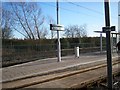
Nottingham NET
Butlers Hill tram station
Image: © norman griffin
Taken: 17 Jan 2009
0.12 miles
10
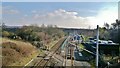
Butler's Hill NET Tram stop alongside the Robin Hood line
Image: © Chris Morgan
Taken: 10 Mar 2014
0.12 miles