IMAGES TAKEN NEAR TO
Papplewick Lane, NOTTINGHAM, NG15 7TN
Introduction
This page details the photographs taken nearby to Papplewick Lane, NG15 7TN by members of the Geograph project.
The Geograph project started in 2005 with the aim of publishing, organising and preserving representative images for every square kilometre of Great Britain, Ireland and the Isle of Man.

There are currently over 7.5m images from over14,400 individuals and you can help contribute to the project by visiting https://www.geograph.org.uk
Image Map
Images are licensed for reuse under creativecommons.org/licenses/by-sa/2.0
Notes
- Clicking on the map will re-center to the selected point.
- The higher the marker number, the further away the image location is from the centre of the postcode.
Image Listing (55 Images Found)
Images are licensed for reuse under creativecommons.org/licenses/by-sa/2.0
Image
Details
Distance
1
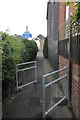
A route 6 twitchell
Between Buckingham Avenue (behind) and Papplewick Lane (forward)
Image: © David Lally
Taken: 27 Apr 2017
0.00 miles
2
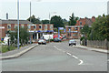
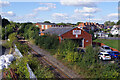
Papplewick Lane
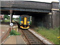
The descent from the railway bridge at Hucknall Station. The original alignment before the coming of the railway would have gone straight past the frontage of the building to the left.
Image: © Alan Murray-Rust
Taken: 7 Jun 2010
0.05 miles
3
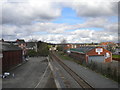
Railway line north of Hucknall
Looking north along the Robin Hood Line, towards Mansfield and Worksop, from the bridge carrying Station Road across the railway line.
Image: © Richard Vince
Taken: 2 Apr 2017
0.08 miles
4
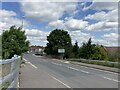
Papplewick Lane in Hucknall
Situated at the western edge of this square close to the railway station.
Image: © Jonathan Clitheroe
Taken: 14 Jun 2022
0.09 miles
5
Railway at Hucknall
Nowadays styled the Robin Hood Line, passenger trains run this way between Nottingham and Mansfield and on to Worksop. The original passenger service was withdrawn in 1964 but the line remained busy with coal trains heading south from Newstead Colliery. After the colliery closed in 1987, the opportunity was taken to reinstate passenger services which happened in stages between 1993 and 1998. The line is nowadays single track between Bestwood Park Junction and Kirkby South Junction. The brick building is the premises of SOS Tyres and Autocare.
Image: © Stephen McKay
Taken: 16 Sep 2022
0.09 miles
6
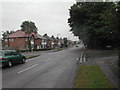
Linby Grove
Late Victorian cul-de-sac off Linby Road.
Image: © Alan Murray-Rust
Taken: 7 Jun 2010
0.09 miles
8
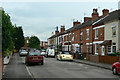
Papplewick Lane, Hucknall
the junction of Papplewick Lane, Leebrook Gardens and Buckingham Avenue
Image: © Tom Courtney
Taken: 13 Aug 2005
0.10 miles
9
Hucknall Departure
Hucknall railway station is directly adjacent to the Nottingham Tramway system terminus. Here, the train for Mansfield Woodhouse departs the rail station
Image: © Chris Eaton
Taken: 11 Jul 2007
0.10 miles
10
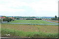
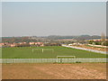
Playing fields
At the back of houses off Papplewick Lane.
Image: © Alan Murray-Rust
Taken: 7 Jun 2010
0.10 miles