IMAGES TAKEN NEAR TO
Cavendish Close, NOTTINGHAM, NG15 7PB
Introduction
This page details the photographs taken nearby to Cavendish Close, NG15 7PB by members of the Geograph project.
The Geograph project started in 2005 with the aim of publishing, organising and preserving representative images for every square kilometre of Great Britain, Ireland and the Isle of Man.

There are currently over 7.5m images from over14,400 individuals and you can help contribute to the project by visiting https://www.geograph.org.uk
Image Map
Images are licensed for reuse under creativecommons.org/licenses/by-sa/2.0
Notes
- Clicking on the map will re-center to the selected point.
- The higher the marker number, the further away the image location is from the centre of the postcode.
Image Listing (24 Images Found)
Images are licensed for reuse under creativecommons.org/licenses/by-sa/2.0
Image
Details
Distance
1
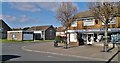
East Side Methodist Church and Bestwood Store
Image: © Chris Morgan
Taken: 10 Mar 2014
0.04 miles
2
Brickyard Drive, Broomhill
Off Bestwood Road.
Image: © Richard Vince
Taken: 2 Apr 2017
0.04 miles
4
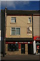
Talking Heads
Gents hairdressers in Hucknall, formerly a music shop if the ghost sign is from a previous owner.
Image: © Graham Hogg
Taken: 10 Mar 2014
0.09 miles
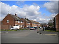
5
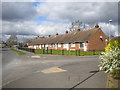
Terraced bungalows on Bestwood Road, Broomhill
Seen from near the junction with Green Close (right).
Image: © Richard Vince
Taken: 2 Apr 2017
0.09 miles
6
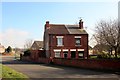
Left standing
Two houses in a Victorian terrace escaped the bulldozer when the new road to the housing estate was constructed.
Image: © Graham Hogg
Taken: 10 Mar 2014
0.09 miles
7
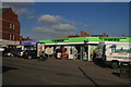
The co-operative co-operating
Food and funeral side by side.
Image: © Graham Hogg
Taken: 10 Mar 2014
0.10 miles
8
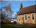
Hucknall, NG15 - Butler's Hill Area
The Yew Tree pub can be seen on the opposite side of Portland Road in this picture taken from the garden at the side of St John's Anglican Church. The church was built in the 1870's to provide for the needs of miners and their families in the Butlers Hill and Broomhill areas of this small market town.
Image: © David Hallam-Jones
Taken: 17 Nov 2012
0.11 miles
9
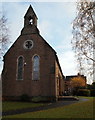
Hucknall, NG15 - Butler's Hill Area
This path at the side of St John’s Anglican Church - a building located on Portland Road - leads to "The Parsonage" that is behind the small tree in the garden. The church was built in the 1870's to provide for the needs of miners and their families in the Butlers Hill and Broomhill areas of Hucknall.
Image: © David Hallam-Jones
Taken: 17 Nov 2012
0.11 miles
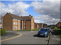
10
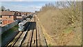
NET tram and Robin Hood line heading north at Butler's Hill
Image: © Chris Morgan
Taken: 10 Mar 2014
0.12 miles