IMAGES TAKEN NEAR TO
Montague Road, NOTTINGHAM, NG15 7DU
Introduction
This page details the photographs taken nearby to Montague Road, NG15 7DU by members of the Geograph project.
The Geograph project started in 2005 with the aim of publishing, organising and preserving representative images for every square kilometre of Great Britain, Ireland and the Isle of Man.

There are currently over 7.5m images from over14,400 individuals and you can help contribute to the project by visiting https://www.geograph.org.uk
Image Map
Images are licensed for reuse under creativecommons.org/licenses/by-sa/2.0
Notes
- Clicking on the map will re-center to the selected point.
- The higher the marker number, the further away the image location is from the centre of the postcode.
Image Listing (79 Images Found)
Images are licensed for reuse under creativecommons.org/licenses/by-sa/2.0
Image
Details
Distance
1
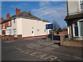
Hucknall - Nottinghamshire
A view of an off-shot cul de sac of Montague Road leading to the main entrance of the National Infants & Junior School.
Image: © David Hallam-Jones
Taken: 20 Mar 2012
0.05 miles

4
Annesley Rd, Hucknall
leading north from Hucknall to Junction 27, M1 and onward to Mansfield.
Image: © Phil Evans
Taken: 22 Jul 2008
0.11 miles
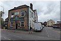
6

Hucknall - Wesleyan Reform Church
On Annesley Road. Opened 1906, closed 2012. For more information on churches in Hucknall, please see http://www.hucknalltorkardhistory.co.uk .
Image: © Dave Bevis
Taken: 15 Dec 2012
0.13 miles
7
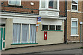
Annesley Road Post Office postbox Ref NG15 2
The siting of this wall box immediately suggests that there was once a post office here, although certainly no longer. The official name for the box confirms this.
Image: © Alan Murray-Rust
Taken: 7 Jun 2010
0.14 miles
8
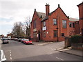
Hucknall - Nottinghamshire
The John Godber Centre, Hucknall, as seen from Ogle Street. The building is a converted church hall that boasts a large hall with a purpose built stage. It also provides premises for some local SureStart children's development programmes and some NHS infant health and welfare services.
Image: © David Hallam-Jones
Taken: 20 Mar 2012
0.14 miles
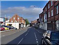
9
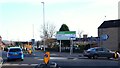
Annesley Rd/Baker St roundabout, Hucknall, Notts.
A feature of the town centre improvement scheme (TCIS). The project aims to develop a pedestrianised section of the High Street between Baker Street and Watnall Road. The scheme received final funding approval from the Department for Transport in February 2015 ("procured using the Medium Scheme Framework 2, through the Midlands Highway Alliance"). Carillion/Tarmac JV were awarded the contract and work started on site in January 2016, with a completion date in May 2017. The scheme aims to reduce traffic congestion, create an attractive shopping centre, attract new retailers and to assist in the regeneration of the town. The blue car looks set to drive along the new relief road on the left, whereas the grey car is about to join Baker Street, where the town’s markets are held.
Image: © David Hallam-Jones
Taken: 17 Dec 2016
0.15 miles
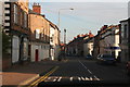
10
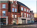
Hucknall - Co-operative Building - Annesley Road frontage
Photo taken from the north-east.
Image: © Dave Bevis
Taken: 15 Dec 2012
0.15 miles