IMAGES TAKEN NEAR TO
Hartington Avenue, NOTTINGHAM, NG15 6TA
Introduction
This page details the photographs taken nearby to Hartington Avenue, NG15 6TA by members of the Geograph project.
The Geograph project started in 2005 with the aim of publishing, organising and preserving representative images for every square kilometre of Great Britain, Ireland and the Isle of Man.

There are currently over 7.5m images from over14,400 individuals and you can help contribute to the project by visiting https://www.geograph.org.uk
Image Map
Images are licensed for reuse under creativecommons.org/licenses/by-sa/2.0
Notes
- Clicking on the map will re-center to the selected point.
- The higher the marker number, the further away the image location is from the centre of the postcode.
Image Listing (24 Images Found)
Images are licensed for reuse under creativecommons.org/licenses/by-sa/2.0
Image
Details
Distance
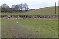
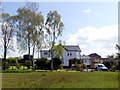
1
Leivers Hill, Hucknall NG15, Notts.
A footpath up or down Leivers Hill can be accessed via the gate in the forefront of this picture, off "The Common" or via a gate on the other side of the farm track between Misk Farm and "The Common" that is being using by a Land Rover in this picture.
Image: © David Hallam-Jones
Taken: 14 Mar 2013
0.12 miles
2
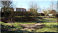
Stainsborough Road, Hucknall NG15, Notts.
At the bottom of the back gardens of these houses on Stainsborough Road, a footpath overlooks an overflow area that serves a nearby water course (i.e. an open drain). At present it is being used by local children as a track for some of their bike-riding activities.
Image: © David Hallam-Jones
Taken: 14 Mar 2013
0.12 miles
5
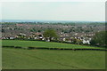
View south from Leivers's Hill
The large estate is collectively known as Ruffs. The name comes from the old farm name, Rough's Farm, but it was clearly felt that the original spelling was not appropriate.
Image: © Alan Murray-Rust
Taken: 21 May 2010
0.14 miles
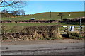
6
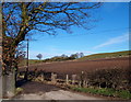
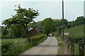
Lievers Hill Area, Hucknall NG15, Notts
This farm track, off "The Common" (road name) very soon leads to Beacon Hill Farm and much later on to Musk Farm occupying a site at the NG15 side of the M1 motorway. The track is described as a "Private Road" although a public footpath runs along its length with a footpath off to the right (within a two minute walk of this point) allowing access up a gentle slope up Leivers Hill, seen in the distance.
Image: © David Hallam-Jones
Taken: 14 Mar 2013
0.14 miles
7
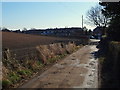
Leivers Hill Area, Hucknall NG15, Notts
Common Lane, visible in the distance, is seen here from the "Private" farm track that serves Misk Farm and Beacon Hill Farm. A public footpath behind the photographer crosses a grazing area on the left, known as Leivers Hill, beyond the ploughed land.
Image: © David Hallam-Jones
Taken: 14 Mar 2013
0.14 miles
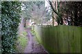
8
The way to Misk Farm
Running along the foot of the southern slopes of Beacon Hill.
Image: © Alan Murray-Rust
Taken: 21 May 2010
0.15 miles
9
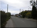
Common Lane, Beauvale
Looking towards Hucknall town centre from the end of the lane to Beacon Hill Farm.
Image: © Richard Vince
Taken: 28 Oct 2017
0.15 miles