IMAGES TAKEN NEAR TO
Willow Avenue, NOTTINGHAM, NG15 6HW
Introduction
This page details the photographs taken nearby to Willow Avenue, NG15 6HW by members of the Geograph project.
The Geograph project started in 2005 with the aim of publishing, organising and preserving representative images for every square kilometre of Great Britain, Ireland and the Isle of Man.

There are currently over 7.5m images from over14,400 individuals and you can help contribute to the project by visiting https://www.geograph.org.uk
Image Map
Images are licensed for reuse under creativecommons.org/licenses/by-sa/2.0
Notes
- Clicking on the map will re-center to the selected point.
- The higher the marker number, the further away the image location is from the centre of the postcode.
Image Listing (3 Images Found)
Images are licensed for reuse under creativecommons.org/licenses/by-sa/2.0
Image
Details
Distance
1
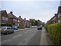
Rushcliffe Road, Ruffs estate
Seen from Nabbs Lane.
Image: © Richard Vince
Taken: 28 Oct 2017
0.17 miles
2
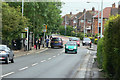
Nabbs Lane
The main feeder road through the estates to the south west of Hucknall. The view was taken when school was coming out.
Image: © Alan Murray-Rust
Taken: 7 Jun 2010
0.19 miles
3
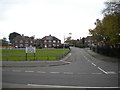
The end of Salterford Road, Ruffs estate
Seen from Nabbs Lane. Salterford Road curls around to meet itself, a little way beyond the bend visible here; this is thus the only way for vehicles to gain the outside world from it.
Image: © Richard Vince
Taken: 28 Oct 2017
0.23 miles