IMAGES TAKEN NEAR TO
Railway Close, NOTTINGHAM, NG15 6EJ
Introduction
This page details the photographs taken nearby to Railway Close, NG15 6EJ by members of the Geograph project.
The Geograph project started in 2005 with the aim of publishing, organising and preserving representative images for every square kilometre of Great Britain, Ireland and the Isle of Man.

There are currently over 7.5m images from over14,400 individuals and you can help contribute to the project by visiting https://www.geograph.org.uk
Image Map
Images are licensed for reuse under creativecommons.org/licenses/by-sa/2.0
Notes
- Clicking on the map will re-center to the selected point.
- The higher the marker number, the further away the image location is from the centre of the postcode.
Image Listing (13 Images Found)
Images are licensed for reuse under creativecommons.org/licenses/by-sa/2.0
Image
Details
Distance
1
Open space off Farleys Lane
The older terraced houses, on Occupation Road, are in marked contrast to their much more modern neighbours - see http://www.geograph.org.uk/photo/1907641 .
Image: © Alan Murray-Rust
Taken: 7 Jun 2010
0.03 miles
2
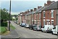
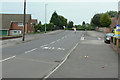
Occupation Road
This and a couple of adjacent streets of terraced houses formed an isolated community, well separated from the main part of Hucknall, for several decades before the main part of the current Hazelgrove estate was developed. The reason for the initial development is the proximity to the old Hucknall No.1 Colliery, for whose workers they would almost certainly have been provided.
Image: © Alan Murray-Rust
Taken: 7 Jun 2010
0.07 miles
3
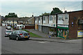
Birchdale Avenue
With local shops serving the Hazelgrove estate.
Image: © Alan Murray-Rust
Taken: 7 Jun 2010
0.07 miles
4
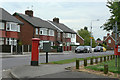
Occupation Road postbox Ref No NG15 6
EIIR (Post Office) standard pillar box at the junction with Farleys Lane.
Image: © Alan Murray-Rust
Taken: 7 Jun 2010
0.10 miles
5
Park Drive railway bridge
The blue brick parapet on the left hand side of the road is now the only evidence that this is where the road crossed the former Great Central Railway main line. The railway trackbed has long since been completely overbuilt with housing. Interestingly, older maps show the bridge with its approaches, including the road junction on the far side, completely unconnected to the road network. Presumably there were already some ideas as to how the road network was expected to evolve.
Image: © Alan Murray-Rust
Taken: 7 Jun 2010
0.15 miles
6
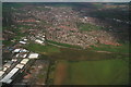
Hucknall: aerial 2014
Taken from above the runway at Hucknall Aerodrome, looking towards Titchfield Park.
Image: © Chris
Taken: 9 Apr 2014
0.16 miles
7
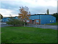
Industrial unit, Benneworth Close, Hucknall
Image: © Jonathan Thacker
Taken: 5 Nov 2023
0.19 miles
8
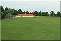
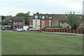
Torkard Park
The southern end of Hucknall's main public park; this area is laid out with football pitches during the winter.
Image: © Alan Murray-Rust
Taken: 7 Jun 2010
0.22 miles
9
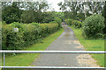
Farm lane off Farleys Lane
Looking at old maps shows that this is in fact the old course of the railway serving Hucknall No.1 Colliery.
Image: © Alan Murray-Rust
Taken: 7 Jun 2010
0.22 miles
10
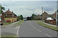
Broomhill Road
1950s/60s housing in the south-eastern sector of the town.
Image: © Alan Murray-Rust
Taken: 7 Jun 2010
0.23 miles