IMAGES TAKEN NEAR TO
Lake View Drive, NOTTINGHAM, NG15 0EA
Introduction
This page details the photographs taken nearby to Lake View Drive, NG15 0EA by members of the Geograph project.
The Geograph project started in 2005 with the aim of publishing, organising and preserving representative images for every square kilometre of Great Britain, Ireland and the Isle of Man.

There are currently over 7.5m images from over14,400 individuals and you can help contribute to the project by visiting https://www.geograph.org.uk
Image Map
Images are licensed for reuse under creativecommons.org/licenses/by-sa/2.0
Notes
- Clicking on the map will re-center to the selected point.
- The higher the marker number, the further away the image location is from the centre of the postcode.
Image Listing (45 Images Found)
Images are licensed for reuse under creativecommons.org/licenses/by-sa/2.0
Image
Details
Distance
1

Holiday Inn hotel (formerly The Dakota)
On the fringes of Sherwood Park industrial estate.
Image: © Steve Fareham
Taken: 6 Dec 2011
0.07 miles
2
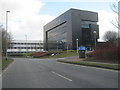
Office block in Sherwood Enterprise Park
Image: © Peter Robinson
Taken: 6 Apr 2013
0.08 miles
3
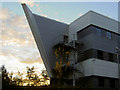
Sherwood Office park #2
Dawn breaks behind architectural office. There are a significant number of interesting buildings on this park.
Image: © Steve Fareham
Taken: 27 Oct 2007
0.09 miles
4
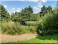
Pond in Sherwood Park
Located next to a roadside hotel near the edge of the business park.
Image: © Jonathan Clitheroe
Taken: 9 Sep 2023
0.11 miles
5
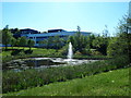
Notts - NG15 (Sherwood Park)
A view across one of the ornamental lakes at the entry to the Sherwood Business Park - off Mansfield Road (A608) - with the Icon conference venue and the roof of the Holiday Inn in the background. The site enjoys the only BREEAM* awarded 'Excellent' environmental rating in the East Midlands. (*Building Research Establishment Environmental Assessment Method certification), that involves a voluntary measurement rating of green buildings.
Image: © David Hallam-Jones
Taken: 26 May 2012
0.11 miles
6
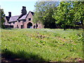
Notts - NG15 (Annesley Hall)
The arched entry into the dilapidated Annesley Hall stable block - taken from the bridle path that extends gently uphill from Annesley Lodge, off the A608 (Mansfield Rd). The Lodge, a difficult to photograph Grade II listed building, is currently home to a Riding School/Stables.
Image: © David Hallam-Jones
Taken: 26 May 2012
0.13 miles
7
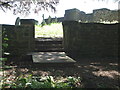
Notts - NG15 (Annesley Hall area)
Although not a very good photograph, it serves to show how non-friendly the access is to the ruins and graveyard of the Grade I-listed former Annesley Church, adjacent to Mansfield Road (A608). There is free parking very nearby on a slip road/cul-de-sac but at present the path into the church yard is unmade and visitors are required to navigate these stone steps into the graveyard. The access board was in place for use by builders with their wheel-barrows and is not normally there. A gardener working nearby seemed disgruntled that several million pounds is currently being spent on preservation work on the church "without any thought" to improving the access.
Image: © David Hallam-Jones
Taken: 26 May 2012
0.14 miles
8
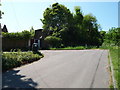
Notts - NG16 (Annesley Hall Area)
This is the cul-de-sac at the conclusion of the slip road that starts 300 metres lower down, as a branch off of the Mansfield Road (A608). Beyond the low wooden barriers is a footpath that runs parallel with one of Annesley Hall's boundary walls. Behind the crudely boarded up carriage entrance lies a courtyard that previously served a wing of Annesley Hall. The 12th century Grade I-listed former Annesley Church lies up an unmade path beyond another cul-de-sac to the left, behind the litter bin.
Image: © David Hallam-Jones
Taken: 26 May 2012
0.14 miles
9
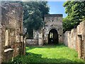
Annesley Old Church - Nave and Belltower
Grade I listed building located next to Annesley Hall, ancestral home of the Chaworth-Muster family of whom, several are buried in the nearby graveyard. The base of the square tower and the oldest 12th century fragments of the church can be seen here in addition to an evergreen Holm oak tree. The church fell into disuse after the new church in Annesley was built in 1874 to accommodate the expanding mining community.
Image: © Jonathan Clitheroe
Taken: 9 Sep 2023
0.14 miles
10
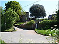
Notts - NG15 (Annesley Hall Area)
This is the cul-de-sac at the end of the slip road that feeds in from the left of this picture. The slip road branches off the Mansfield Road. To the right (behind the cow parsley) is a low barrier and the start of a footpath that follows one of Annesley Hall's boundary walls. Behind the crudely boarded up entrance lies a courtyard that previously served a wing of Annesley Hall; in the centre of the picture is the tower of the 12th century former Annesley Church and beyond the up-ended wooden pallet lies an unmade path that leads to some steps, the graveyard and ultimately the ruined church.
Image: © David Hallam-Jones
Taken: 26 May 2012
0.15 miles