IMAGES TAKEN NEAR TO
Derby Road, NOTTINGHAM, NG15 0AQ
Introduction
This page details the photographs taken nearby to Derby Road, NG15 0AQ by members of the Geograph project.
The Geograph project started in 2005 with the aim of publishing, organising and preserving representative images for every square kilometre of Great Britain, Ireland and the Isle of Man.

There are currently over 7.5m images from over14,400 individuals and you can help contribute to the project by visiting https://www.geograph.org.uk
Image Map
Images are licensed for reuse under creativecommons.org/licenses/by-sa/2.0
Notes
- Clicking on the map will re-center to the selected point.
- The higher the marker number, the further away the image location is from the centre of the postcode.
Image Listing (31 Images Found)
Images are licensed for reuse under creativecommons.org/licenses/by-sa/2.0
Image
Details
Distance
1
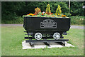
Annesley Colliery memorial
Situated by Annesley Cutting which provided the main vehicular access to the former colliery.
Image: © Bill Boaden
Taken: 2 Jul 2022
0.09 miles
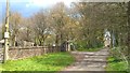
2
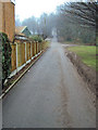
Entrance road to All Saints Church
Looking east along the entrance road to church and cemetery. The church is just in view at the end of the road in the trees. Houses on Stonechurch View on the left.
Image: © Trevor Rickard
Taken: 6 Feb 2010
0.10 miles
3
Annesley NG15, Notts.
Annesley Cutting can be seen on the other side of the grassed area. A modern 'replacement' Vicarage is also situated on the other side of the road. This is a view from the side of the All Saints Church's Parish Hall.
Image: © David Hallam-Jones
Taken: 28 Feb 2013
0.10 miles
4
Annesley NG15, Notts.
All Saints Church Hall and the cemetery and its Chapel of Rest, with All Saints (Anglican) Church in the distance. The parish cemetery for Annesley and Felley was established here in 1872. The driveway commences on Annesley Cutting, almost immediately behind the photographer.
Image: © David Hallam-Jones
Taken: 28 Feb 2013
0.10 miles
5

Annesley NG15, Notts.
The entrance to the cemetery that serves the parishes of Annesley and Felley is visible on the right as is the Church Hall belonging to All Saints (Anglican) Church. The road at the foot of the drive is Annesley Cutting that links to Derby Road (A611) a minute away on the right.
Image: © David Hallam-Jones
Taken: 28 Feb 2013
0.11 miles
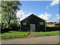
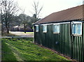
8
All Saints Church Hall
At the bottom of the drive up to All Saints' Church.
Image: © Bill Boaden
Taken: 2 Jul 2022
0.12 miles
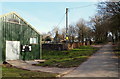
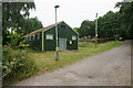
9
Annesley & Felley Parish Cemetery
An active cemetery with a mortuary chapel in the centre, operated by Annesley & Felley Parish Council.
Image: © Bill Boaden
Taken: 2 Jul 2022
0.12 miles
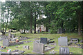
10

Annesley Cemetery
Looking north east towards the Chapel of Rest
Image: © Graham Hogg
Taken: 3 May 2016
0.12 miles