IMAGES TAKEN NEAR TO
Byron Road, NOTTINGHAM, NG15 0AH
Introduction
This page details the photographs taken nearby to Byron Road, NG15 0AH by members of the Geograph project.
The Geograph project started in 2005 with the aim of publishing, organising and preserving representative images for every square kilometre of Great Britain, Ireland and the Isle of Man.

There are currently over 7.5m images from over14,400 individuals and you can help contribute to the project by visiting https://www.geograph.org.uk
Image Map
Images are licensed for reuse under creativecommons.org/licenses/by-sa/2.0
Notes
- Clicking on the map will re-center to the selected point.
- The higher the marker number, the further away the image location is from the centre of the postcode.
Image Listing (50 Images Found)
Images are licensed for reuse under creativecommons.org/licenses/by-sa/2.0
Image
Details
Distance
1
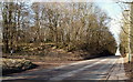
Annesley Cutting NG15, Notts.
To the left is an entrance/exit for forestry vehicles, cyclists and walkers using the Annesley Plantation (a.k.a. Annesley Forest). Derby Road (the A611) is a 5 minute walk away - straight ahead - whilst parts of Annesley are behind the photographer, as is Newstead village (by road). These are former pit villages.
Image: © David Hallam-Jones
Taken: 28 Feb 2013
0.08 miles
2

Byron Road, Annesley Village, looking north
Image: © Antony Dixon
Taken: 27 Jul 2016
0.08 miles
3
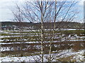
Annesley Rows
Annesley Rows taken from the old pit tip
Image: © GARY ROE
Taken: 30 Mar 2013
0.10 miles
4
Descending path towards Annesley Cutting
Image: © Chris Morgan
Taken: 3 May 2016
0.10 miles
5
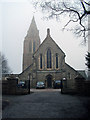
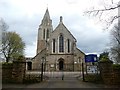
All Saints Church
The church was erected in 1874 when the centre of population of the parish moved with the sinking of Annesley colliery in 1869. The old church a mile to the south-west near Annesley Hall is now a ruin.
http://www.ashfield-dc.gov.uk/ccm/navigation/community-and-living/faiths--beliefs-and-religions/annesley-all-saints-church/;jsessionid=D3CB30B94F96918EBFC5606AEC35C741
Image: © Trevor Rickard
Taken: 6 Feb 2010
0.10 miles
6
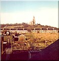
Annesley Church 1976
A view of Annesley All Saints Church from my old house.
Image: © GARY ROE
Taken: 22 Jan 2011
0.11 miles
7
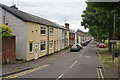
Moseley Road
A line of cottages in the former mining village of Annesley.
Image: © Bill Boaden
Taken: 2 Jul 2022
0.11 miles
8

All Saints' church, Annesley
Designed by T.G. Jackson 1874 https://historicengland.org.uk/listing/the-list/list-entry/1275939
Image: © Jonathan Thacker
Taken: 10 May 2021
0.12 miles