IMAGES TAKEN NEAR TO
Recreation Road, NOTTINGHAM, NG15 0AE
Introduction
This page details the photographs taken nearby to Recreation Road, NG15 0AE by members of the Geograph project.
The Geograph project started in 2005 with the aim of publishing, organising and preserving representative images for every square kilometre of Great Britain, Ireland and the Isle of Man.

There are currently over 7.5m images from over14,400 individuals and you can help contribute to the project by visiting https://www.geograph.org.uk
Image Map
Images are licensed for reuse under creativecommons.org/licenses/by-sa/2.0
Notes
- Clicking on the map will re-center to the selected point.
- The higher the marker number, the further away the image location is from the centre of the postcode.
Image Listing (28 Images Found)
Images are licensed for reuse under creativecommons.org/licenses/by-sa/2.0
Image
Details
Distance

2

Green space in the middle of Annesley Village
Image: © Antony Dixon
Taken: 27 Jul 2016
0.05 miles
3

Byron Road, Annesley
Heading towards Annesley Cutting.
Image: © JThomas
Taken: 16 Apr 2010
0.08 miles
4
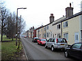
Annesley Village
Looking south along Byron Road. This road and the parallel Moseley Road on the other side of the green form the main part of Annesley Village. The new village was built by the Annesley Colliery Company in 1860 for its employees when the company sunk the two nearby Annesley mine shafts - Image The layout is spacious, allowing plenty of land for vegetable plots, and was seen as progressive for its day. During 1999 the district council recognised the importance of Annesley Village and colliery pit head by including it as a conservation area. This appeared to provide a measure of protection to the colliery buildings, but as can be seen this proved not to be the case - see Image and Image
http://www.forlornbritain.co.uk/annesley.php
Image: © Trevor Rickard
Taken: 6 Feb 2010
0.09 miles
5
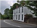
Old Post Office B&B, Newstead
The Old PO B&B in the centre of Newstead village.
Image: © Phil Evans
Taken: 24 Jul 2008
0.10 miles
6
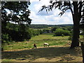
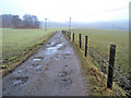
Annesley - fields above Mosley Farm
For a winter-time view of a similar location, please see Image
Image: © Dave Bevis
Taken: 11 Jun 2011
0.12 miles
7

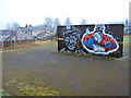
Annesley village artwork - 1
Next to the playing field and looking north to this brightly painted wall, which contrasts the greyness of this misty day. Children's play area behind the wall.
See Image for the reverse side.
Image: © Trevor Rickard
Taken: 6 Feb 2010
0.12 miles
8
Annesley village artwork - 2
Looking south-east to the painted wall and the houses on Byron Road behind. As the council has totally mismanaged the preservation of Annesley Colliery headstocks and buildings (see - Image and Image), this becomes an even more poignant reminder of the former importance of this area. It will be interesting to see how well it weathers.
See Image for the reverse side.
Image: © Trevor Rickard
Taken: 6 Feb 2010
0.12 miles
9
Track north of Annesley Village
Heading north into the mist and to the riding school on the right just across the railway.
Image: © Trevor Rickard
Taken: 6 Feb 2010
0.12 miles
10
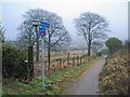
Cycleway and footpath to Newstead
From the end of School Hill leading east down the hill to Annesley Village.
Image: © Trevor Rickard
Taken: 6 Feb 2010
0.13 miles