IMAGES TAKEN NEAR TO
Addison Street, NOTTINGHAM, NG1 4GX
Introduction
This page details the photographs taken nearby to Addison Street, NG1 4GX by members of the Geograph project.
The Geograph project started in 2005 with the aim of publishing, organising and preserving representative images for every square kilometre of Great Britain, Ireland and the Isle of Man.

There are currently over 7.5m images from over14,400 individuals and you can help contribute to the project by visiting https://www.geograph.org.uk
Image Map
Images are licensed for reuse under creativecommons.org/licenses/by-sa/2.0
Notes
- Clicking on the map will re-center to the selected point.
- The higher the marker number, the further away the image location is from the centre of the postcode.
Image Listing (395 Images Found)
Images are licensed for reuse under creativecommons.org/licenses/by-sa/2.0
Image
Details
Distance
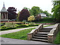
1
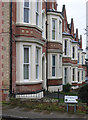
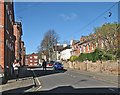
Nottingham - terrace on Addison Street
Part of Nottingham City's Arboretum Conservation Area - see http://www.nottinghamcity.gov.uk/CHttpHandler.ashx?id=25588&p=0 .
Image: © Dave Bevis
Taken: 25 Feb 2013
0.00 miles
2
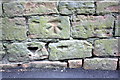
Benchmark on the wall of Addison Street
Weathered Ordnance Survey cut mark benchmark described on the Bench Mark Database at http://www.bench-marks.org.uk/bm42605
Image: © Roger Templeman
Taken: 8 Apr 2012
0.02 miles
3
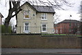
#26 Annesley Grove, Addison Street
There is an OS benchmark Image on the wall near the middle of the image.
Image: © Roger Templeman
Taken: 8 Apr 2012
0.02 miles
4
Nottingham - NG1 (Arboretum Area)
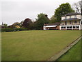
The premises of the Nottingham Proprietary Bowling Green Club are located at 29, Addison Street. This club was constructed on former farm land - circa 1901 - by a group of city mill owners and industrialists for their benefit and that of their families. The pointed roof and the coloured tiles of the Chinese Bell Tower are visible in the adjacent Arboretum.
Image: © David Hallam-Jones
Taken: 20 May 2012
0.04 miles
5
Nottingham - NG1 (Arboretum)
A corner of the memorial garden on the High School side of the arboretum showing the Chinese Bell Tower and the Sebastapol cannons. Beyond the hedge the clubhouse of the Nottingham Proprietary Bowling Green Club can be seen. The entrance to this private lawn bowls club is at No.29 Addison Street. It seems that the club was developed on some former farm land - circa 1901 - by a collection of city mill owners and industrialists for their exclusive benefit and that of their families.
Image: © David Hallam-Jones
Taken: 20 May 2012
0.05 miles
6
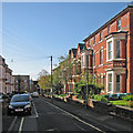
Clipstone Avenue
The dome of The Council House shows above the roofs more or less at the vanishing point. In "The Illustrated History of Nottingham's Suburbs" Geoffrey Oldfield describes "a short, secluded row between Peel Street [ahead] and Annesley Grove", adding that in 1881 "four of the thirteen houses on the east [left] side were occupied by nonconformist clergymen".
Image: © John Sutton
Taken: 3 May 2016
0.05 miles
7
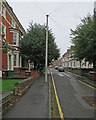
Up Clipstone Avenue
A view from the Peel Street end. The suburbs north of the mediaeval centre of Nottingham were some of the first to be developed in the decades after the 1845 Enclosure Act.
Image: © John Sutton
Taken: 11 Sep 2018
0.05 miles
8
Nottingham - terrace on Clipstone Avenue
Part of Nottingham City's Arboretum Conservation Area - see
http://www.nottinghamcity.gov.uk/CHttpHandler.ashx?id=25588&p=0 .
Image: © Dave Bevis
Taken: 25 Feb 2013
0.05 miles
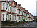
9
Annesley Grove
The houses on the right date from the initial expansion of the city in the middle of the nineteenth century, the trainers dangling from the telephone wire from the first part of the twenty-first.
Image: © John Sutton
Taken: 3 May 2016
0.06 miles
10
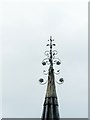
Detail of the Chinese Bell Tower, Nottingham Arboretum
The delicately detailed cap to the spire.
See http://www.geograph.org.uk/photo/6229843 for location.
Image: © Alan Murray-Rust
Taken: 26 Jul 2019
0.06 miles