IMAGES TAKEN NEAR TO
North Sherwood Street, NOTTINGHAM, NG1 4EW
Introduction
This page details the photographs taken nearby to North Sherwood Street, NG1 4EW by members of the Geograph project.
The Geograph project started in 2005 with the aim of publishing, organising and preserving representative images for every square kilometre of Great Britain, Ireland and the Isle of Man.

There are currently over 7.5m images from over14,400 individuals and you can help contribute to the project by visiting https://www.geograph.org.uk
Image Map
Images are licensed for reuse under creativecommons.org/licenses/by-sa/2.0
Notes
- Clicking on the map will re-center to the selected point.
- The higher the marker number, the further away the image location is from the centre of the postcode.
Image Listing (354 Images Found)
Images are licensed for reuse under creativecommons.org/licenses/by-sa/2.0
Image
Details
Distance
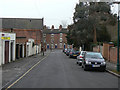
1
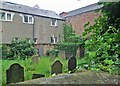
Jewish Cemetery, North Sherwood Street
This was the camera's view but not mine as I held it at arm's length and pointed it over the high Bulwell stone wall shown in David Hallam-Jones's Image The cemetery was in use from 1882-9.
Image: © John Sutton
Taken: 23 Jun 2013
0.02 miles
2
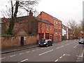
Nottingham - NG1
The Forest Road East end of North Sherwood Street is seen here. Above the padlocked door in the sandstone wall on the left is a marble tablet bearing a scriptural text that also reads : “This burial ground was given to the Nottingham Jewish community by the Corporation of Nottingham in 1882. It was closed in 1889”. The Lord Mayor, Mr Oldknow, laid the first stone of the inclosure wall during a ceremony on 26 February 1823. By 1839 it seems that there was a community of seven Jewish families living in Nottingham who worshipped in a private home, whereas by 1895 the community had swollen to 500 families. During a later part of the 19th century there had been an influx of German Jews into Nottingham, as was the case in many other industrial cities. One notable personality was Lewis Heymann (1803-66) from Hamburg who became head of Heymann & Alexander in Stoney Street. He has been described as one of the pioneers of the Nottingham lace curtain industry. He also served as Mayor for a time. He died in 1869, aged 66, and was buried in the General Cemetery, as opposed to here in this small plot of 144 sq.yds.
Image: © David Hallam-Jones
Taken: 28 Apr 2012
0.02 miles
3
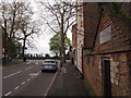
Nottingham - NG1
The junction of N. Sherwood St with Forest Road East is seen here, with the boundary fence of Church (“The Rock”) Cemetery in the distance. Above the padlocked door on the right there is a marble tablet set into the sandstone wall bearing a scriptural text that also reads : “This burial ground was given to the Nottingham Jewish community by the Corporation of Nottingham in 1882. It was closed in 1889”. By 1839 there was a community of seven Jewish families living in Nottingham who worshipped in a private home, whereas by 1895 the community had swollen to 500 families. Later on in the 19th century there had been an influx of German Jews into Nottingham, as was the case in many other industrial cities. One notable personality was Lewis Heymann (1803-66) from Hamburg who became head of Heymann & Alexander in Stoney Street. He has been described as one of the pioneers of the Nottingham lace curtain industry. He also served as Mayor for a time. He died in 1869, aged 66, and was buried in the General Cemetery, as opposed to here in this small plot of 144 sq.yds.
Image: © David Hallam-Jones
Taken: 28 Apr 2012
0.02 miles
4
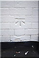
Benchmark on #252 North Sherwood Road
Ordnance Survey cut mark benchmark described on the Bench Mark Database at http://www.bench-marks.org.uk/bm47853
Image: © Roger Templeman
Taken: 30 Mar 2013
0.02 miles
5
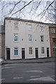
White-painted houses on North Sherwood Street
There is an OS benchmark Image on the wall to the right of the left hand door
Image: © Roger Templeman
Taken: 30 Mar 2013
0.02 miles
6
Nottingham - Mansfield Road (around No 243)
For a further views of Mansfield Road in this area, please see Alan Murray-Rust's set of photos, starting at Image
Image: © Dave Bevis
Taken: 25 Feb 2013
0.02 miles
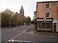
7
Nottingham - Mansfield Road (around The Maze pub)
For a further views of Mansfield Road in this area, please see Alan Murray-Rust's set of photos, starting at Image
Image: © Dave Bevis
Taken: 25 Feb 2013
0.03 miles
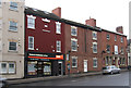
8
Nottingham - NG1
North Sherwood Street joins Forest Road East at this point. “Brown Esq. Barbers” has ceased to function. On the left is the boundary fence of Church (a.k.a. The Rock”) Cemetery and directly ahead, at the junction of Forest Road East and Mansfield Road (A60),‘St Andrew’s on the Rock’, an Anglican parish church is glaringly obvious.
Image: © David Hallam-Jones
Taken: 28 Apr 2012
0.03 miles
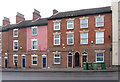
9
Villa Road
Looking towards Mansfield Road. This is the opposite direction to Image and there is a stark contrast between the type of housing at the opposite ends.
Image: © Alan Murray-Rust
Taken: 8 Mar 2009
0.03 miles
10

Forest Tavern/ The Maze, Nottingham
Forest tavern is a public house attached to the Maze, a live music venue.
Image: © Chris Whippet
Taken: 28 Jul 2015
0.03 miles