IMAGES TAKEN NEAR TO
Ossington Close, NOTTINGHAM, NG1 4EU
Introduction
This page details the photographs taken nearby to Ossington Close, NG1 4EU by members of the Geograph project.
The Geograph project started in 2005 with the aim of publishing, organising and preserving representative images for every square kilometre of Great Britain, Ireland and the Isle of Man.

There are currently over 7.5m images from over14,400 individuals and you can help contribute to the project by visiting https://www.geograph.org.uk
Image Map
Images are licensed for reuse under creativecommons.org/licenses/by-sa/2.0
Notes
- Clicking on the map will re-center to the selected point.
- The higher the marker number, the further away the image location is from the centre of the postcode.
Image Listing (441 Images Found)
Images are licensed for reuse under creativecommons.org/licenses/by-sa/2.0
Image
Details
Distance
1
Peel Street: cave entrance
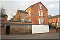
The concrete-roofed doorway is the entrance to the former Rouse's Sand Mines, which flourished c. 1780-1810. Later in the 19th century, their origin having been forgotten, fanciful and unscrupulous entrepreneurs opened the caves as a tourist attraction, the credulous paying to enter "Robin Hood's Mammoth Cave", which at Goose Fair time was transformed with lights to "a scene in fairy land". During the Second World War the caves - along with 75 others in the city - became air-raid shelters. This is the northern entrance dug then. A sloping tunnel, protected by brick blast walls, leads down to the main galleries. The blockhouse entrance is relatively new, dating from road widening at the time these houses were built.
The Mansfield Road area was, in the 18th and 19th centuries, the site of a number of sand mines, some remains of three of which may still be seen (a fourth has been filled with concrete). Google “Nottingham Sand Mines” to download a PDF of Tony Waltham’s “The Sand Mines of Nottingham”, which tells the full story. The sand mined here was, apparently, spread on household floors in the days before carpets (people alive in the 1940s had childhood memories of cart men touring the streets to sell “lily-white sand”), and supplied to the bottle-glass works which thrived in Nottingham in the 18th century. Mining ceased in the 19th century and the caves were later put to other uses – the most obvious being the Church (Rock) cemetery on Forest Road http://www.geograph.org.uk/photo/1196538
Image: © John Sutton
Taken: 22 Apr 2010
0.04 miles
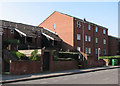
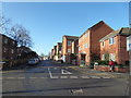
2
Peel Street and Birkland and Clipstone Avenues
The two terraces are approached by steps at their Peel Street ends. Vehicle access is from Annesley Grove.
Image: © John Sutton
Taken: 3 May 2016
0.04 miles
3
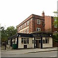
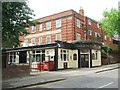
The Hole in the Wall, North Sherwood Street, Nottingham
Moderne-style Georgian revival pub. The single storey extension to the left is a later addition, on the site of the former Huskinson Street which disappeared during 1960s redevelopment of the area.
Image: © Alan Murray-Rust
Taken: 12 Aug 2019
0.04 miles
4
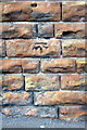
Benchmark on the wall on the north side of Peel Street
Ordnance Survey cut mark benchmark described on the Bench Mark Database at http://www.bench-marks.org.uk/bm47845
Image: © Roger Templeman
Taken: 30 Mar 2013
0.05 miles
5
Peel Street
There is an OS benchmark Image on the stone wall about 2m right of the metal gate
Image: © Roger Templeman
Taken: 30 Mar 2013
0.05 miles
7
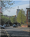
A spring morning in Dryden Street
Looking south towards the city centre and the prominent landmark of the Newton Building of Nottingham Trent University. To its left is the roof of the Royal Centre, and to the left of that, on the skyline eight miles or so to the south, one of the wooded hills of the South Notts Wolds.
Image: © John Sutton
Taken: 3 May 2016
0.05 miles
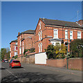
8
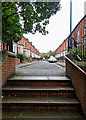
Up the steps to Birkland Avenue
A view from the Peel Street end. The suburbs north of the mediaeval centre of Nottingham were some of the first to be developed in the decades after the 1845 Enclosure Act. Nottingham brick is a good colour even on a dreary day.
Image: © John Sutton
Taken: 11 Sep 2018
0.05 miles
9
Part of Peel Street, Nottingham
A weary postie rests his bones on the end of the street.
Image: © Jeremy Bolwell
Taken: 18 Jan 2020
0.06 miles
10
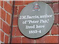
Plaque to J M Barrie (author)
On wall of number 5 recording his short residence at the address.
Image: © El Loco
Taken: 2 Jan 2021
0.06 miles