IMAGES TAKEN NEAR TO
Gibsmere, NG14 7LS
Introduction
This page details the photographs taken nearby to Gibsmere, NG14 7LS by members of the Geograph project.
The Geograph project started in 2005 with the aim of publishing, organising and preserving representative images for every square kilometre of Great Britain, Ireland and the Isle of Man.

There are currently over 7.5m images from over14,400 individuals and you can help contribute to the project by visiting https://www.geograph.org.uk
Image Map
Images are licensed for reuse under creativecommons.org/licenses/by-sa/2.0
Notes
- Clicking on the map will re-center to the selected point.
- The higher the marker number, the further away the image location is from the centre of the postcode.
Image Listing (12 Images Found)
Images are licensed for reuse under creativecommons.org/licenses/by-sa/2.0
Image
Details
Distance
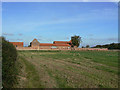
1

Glebe Farm on the road from Gibsmere
The tarred road ends at the farm, but continues as a bridleway to Hoveringham.
Image: © Tim Heaton
Taken: 1 Nov 2008
0.03 miles
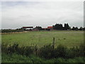
2
Glebe Farm
Seen from the south west. The farm has been converted to residential use with several new buildings added.
Image: © Alan Murray-Rust
Taken: 13 Oct 2009
0.03 miles
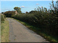
3
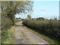
Lane to Glebe Farm
Marked as a bridleway, repairs to the road surface suggest that it is still maintainable at public expense.
Image: © Alan Murray-Rust
Taken: 13 Oct 2009
0.06 miles
4
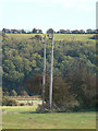
Bird boxes
Thanks to Hugh Venables for identifying these as being for Barn Owls. Apparently having two boxes close together allows the male to roost separately from the female and brood.
Image: © Alan Murray-Rust
Taken: 13 Oct 2009
0.07 miles
5
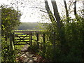
Gated path near Gibsmere and river trent
Image: © Andy Jamieson
Taken: 24 Oct 2008
0.15 miles
6

Bridleway to the Trent at Gibsmere
Image: © Jonathan Thacker
Taken: 27 Nov 2019
0.16 miles
7
Glebe Farm, Gibsmere
south west of the hamlet and surrounded by gravel pits
Image: © Tom Courtney
Taken: 7 Sep 2005
0.17 miles
8

Old tractor and baler at work in small paddocks
Image: © Chris Morgan
Taken: 26 Jul 2016
0.19 miles
9
The end of the road?
At this point the road changes from yellow to white on the OS map and is marked as a bridleway. However, repairs to the road surface suggest that it is still maintainable at public expense, and there is no notice to indicate a change of status.
Image: © Alan Murray-Rust
Taken: 13 Oct 2009
0.19 miles
10

Hay baling near Glebe Farm
An elderly tractor and baler but still doing a good job
Image: © Graham Hogg
Taken: 26 Jul 2016
0.21 miles