IMAGES TAKEN NEAR TO
Lodgefield Lane, NOTTINGHAM, NG14 7JQ
Introduction
This page details the photographs taken nearby to Lodgefield Lane, NG14 7JQ by members of the Geograph project.
The Geograph project started in 2005 with the aim of publishing, organising and preserving representative images for every square kilometre of Great Britain, Ireland and the Isle of Man.

There are currently over 7.5m images from over14,400 individuals and you can help contribute to the project by visiting https://www.geograph.org.uk
Image Map
Images are licensed for reuse under creativecommons.org/licenses/by-sa/2.0
Notes
- Clicking on the map will re-center to the selected point.
- The higher the marker number, the further away the image location is from the centre of the postcode.
Image Listing (24 Images Found)
Images are licensed for reuse under creativecommons.org/licenses/by-sa/2.0
Image
Details
Distance
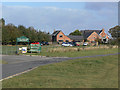
1
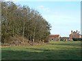
Strange earthwork and Lodgefield House
The earthwork at the left of the picture forms a rough 'C' shape around three sides of a pond. There's no indication on OS maps that it is particularly old, so it's a bit of a mystery. A possible answer is that it was a decoy pond, but it is on the small side for that, and at the largest scale the pond does not have the side trails that are typical of a decoy.
Image: © Alan Murray-Rust
Taken: 13 Oct 2009
0.05 miles
2
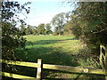
Footpath past Lodgefield House
To the east of Lodgefield House the footpath is following a farm track which passes directly past the house. However, this track becomes a private road at that point, leaving the footpath to follow three sides of a rectangle before joining the lane again. This is the section of the path running parallel to the lane.
Image: © Alan Murray-Rust
Taken: 13 Oct 2009
0.07 miles
3
Footpath junction
The waymark in the hedge is provided by the Country Landowners Association, and includes the word 'welcome'.
Image: © Alan Murray-Rust
Taken: 13 Oct 2009
0.15 miles
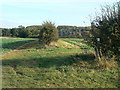
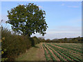
4
Causeway Dyke
Seen here running past the east side of Hoveringham.
Image: © Alan Murray-Rust
Taken: 13 Oct 2009
0.17 miles
5
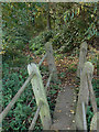
Footbridge over Causeway Dyke
This type of bridge consisting of a simple concrete beam with concrete handrail supports bolted on is fairly common in the area. This one has had at least one support replaced in timber. The footpath provides a link from Main Street down towards the old ferry.
Image: © Alan Murray-Rust
Taken: 13 Oct 2009
0.18 miles
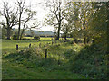
6
Field footpath near Hoveringham
This now forms part of a closed loop, possibly because the original line has been cut by the gravel extraction.
Image: © Alan Murray-Rust
Taken: 13 Oct 2009
0.19 miles
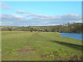
7

Water's Edge and The Old Elm Tree
Beside the River Trent at Hoveringham
Image: © Graham Hogg
Taken: 26 Jul 2016
0.20 miles
9
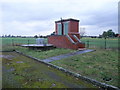
Sewage pumping station, Boat Lane, Hoveringham
Image: © Tim Heaton
Taken: 1 Nov 2008
0.21 miles
10
Ferry Farm Park
The farm now operates as a farm park with a variety of animal species in paddocks.
Image: © Alan Murray-Rust
Taken: 16 Oct 2009
0.21 miles