IMAGES TAKEN NEAR TO
Gonalston Lane, NOTTINGHAM, NG14 7JH
Introduction
This page details the photographs taken nearby to Gonalston Lane, NG14 7JH by members of the Geograph project.
The Geograph project started in 2005 with the aim of publishing, organising and preserving representative images for every square kilometre of Great Britain, Ireland and the Isle of Man.

There are currently over 7.5m images from over14,400 individuals and you can help contribute to the project by visiting https://www.geograph.org.uk
Image Map
Images are licensed for reuse under creativecommons.org/licenses/by-sa/2.0
Notes
- Clicking on the map will re-center to the selected point.
- The higher the marker number, the further away the image location is from the centre of the postcode.
Image Listing (33 Images Found)
Images are licensed for reuse under creativecommons.org/licenses/by-sa/2.0
Image
Details
Distance
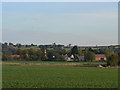
1
West Farm, Hoveringham
Seen from the footpath leading out of the village cricket ground. The farm buildings are now converted to residential use.
Image: © Alan Murray-Rust
Taken: 13 Oct 2009
0.01 miles
2
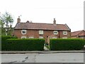
St Michael's Farmhouse, Hoveringham
Mid 18th century, originally two or three cottages, later consolidated into a single farmhouse, Listed Grade II.
Image: © Alan Murray-Rust
Taken: 17 May 2021
0.03 miles
3
St Michaels Church, Gonalston Lane, Hoveringham
Image: © Tom Courtney
Taken: 17 Aug 2005
0.05 miles
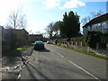
4
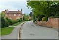
Gonalston Lane, Hoveringham
Looking west.
Image: © Alan Murray-Rust
Taken: 17 May 2021
0.05 miles
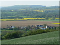
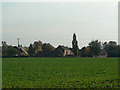
6
Hoveringham village
Seen from the bridleway which passes along the southern edge of the old gravel workings.
On the far left skyline can be seen the tower of Kneeton Church Image on the far side of the River Trent.
Image: © Alan Murray-Rust
Taken: 13 Oct 2009
0.06 miles
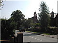
8
St Michaels Church, Gonalston Lane, Hoveringham
Recreating this 'First' for the square https://www.geograph.org.uk/photo/38945 , although the birch tree has grown to a point where the church is hardly visible.
Image: © Alan Murray-Rust
Taken: 15 Jul 2021
0.13 miles
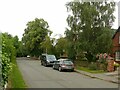
9
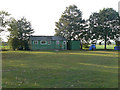
The old pavilion
At Hoveringham Cricket Club.
Members will certainly be looking forward to the replacement in 2010 http://www.geograph.org.uk/photo/1536246.
Image: © Alan Murray-Rust
Taken: 13 Oct 2009
0.13 miles
10
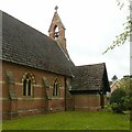
St Michael's Church, Hoveringham ? 3
The north side showing the porch and bellcote.
Built in 1865/66 as a replacement for a medieval church which had become very dilapidated. There is a suggestion that a small amount of medieval walling is incorporated in the brickwork but this has never been verified. Listed Grade II.
Image: © Alan Murray-Rust
Taken: 17 May 2021
0.13 miles