IMAGES TAKEN NEAR TO
Priory Road, NOTTINGHAM, NG14 7GU
Introduction
This page details the photographs taken nearby to Priory Road, NG14 7GU by members of the Geograph project.
The Geograph project started in 2005 with the aim of publishing, organising and preserving representative images for every square kilometre of Great Britain, Ireland and the Isle of Man.

There are currently over 7.5m images from over14,400 individuals and you can help contribute to the project by visiting https://www.geograph.org.uk
Image Map
Images are licensed for reuse under creativecommons.org/licenses/by-sa/2.0
Notes
- Clicking on the map will re-center to the selected point.
- The higher the marker number, the further away the image location is from the centre of the postcode.
Image Listing (2 Images Found)
Images are licensed for reuse under creativecommons.org/licenses/by-sa/2.0
Image
Details
Distance
1
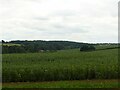
Priory Dumbles, at Thurgarton
Recreating this 'First' for the square https://www.geograph.org.uk/photo/38961 although not from quite the same location. My view was limited by the well-grown hedge along this section of the bridleway.
Image: © Alan Murray-Rust
Taken: 15 Jul 2021
0.21 miles
2
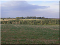
View from the ridge
Looking down into Priory or Thurgarton Dumble from the bridleway to Epperstone.
Image: © Alan Murray-Rust
Taken: 24 Sep 2009
0.24 miles