IMAGES TAKEN NEAR TO
Gibsmere, NOTTINGHAM, NG14 7FS
Introduction
This page details the photographs taken nearby to Gibsmere, NG14 7FS by members of the Geograph project.
The Geograph project started in 2005 with the aim of publishing, organising and preserving representative images for every square kilometre of Great Britain, Ireland and the Isle of Man.

There are currently over 7.5m images from over14,400 individuals and you can help contribute to the project by visiting https://www.geograph.org.uk
Image Map
Images are licensed for reuse under creativecommons.org/licenses/by-sa/2.0
Notes
- Clicking on the map will re-center to the selected point.
- The higher the marker number, the further away the image location is from the centre of the postcode.
Image Listing (20 Images Found)
Images are licensed for reuse under creativecommons.org/licenses/by-sa/2.0
Image
Details
Distance
1
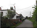
Gibsmere Village
Just one road through this tiny hamlet near the side of the Trent
Image: © Tom Courtney
Taken: 7 Sep 2005
0.02 miles
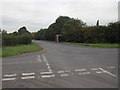
2
Gibsmere
View from the Trent Valley Way to the hamlet of Gibsmere in Bleasy parish
Image: © Richard Croft
Taken: 10 Jul 2010
0.06 miles
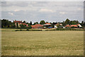
3
Gibsmere hamlet
Seen from the bank of the River Trent.
Image: © Alan Murray-Rust
Taken: 13 Oct 2009
0.06 miles
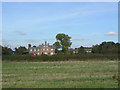
4
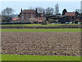
Farm at Gibsmere viewed from the Trent Valley Way
Image: © Mat Fascione
Taken: 25 Mar 2016
0.07 miles
5

Flying the flag at Gibsmere
The royal coat of arms in the Union flag
Image: © Chris Morgan
Taken: 26 Jul 2016
0.08 miles

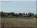
7
Gibsmere hamlet
Once little more than a large farm with associated cottages, there is now quite a bit of additional modern housing.
Image: © Alan Murray-Rust
Taken: 13 Oct 2009
0.11 miles
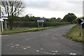
9
Country Bus Shelter
At the cross roads of Boat Lane and Main St, Bleasby, the shelter is very handy for the near by caravan park
Image: © Tom Courtney
Taken: 7 Sep 2005
0.15 miles
10
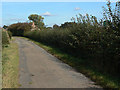
The end of the road?
At this point the road changes from yellow to white on the OS map and is marked as a bridleway. However, repairs to the road surface suggest that it is still maintainable at public expense, and there is no notice to indicate a change of status.
Image: © Alan Murray-Rust
Taken: 13 Oct 2009
0.17 miles