IMAGES TAKEN NEAR TO
Trentside, NOTTINGHAM, NG14 7FB
Introduction
This page details the photographs taken nearby to Trentside, NG14 7FB by members of the Geograph project.
The Geograph project started in 2005 with the aim of publishing, organising and preserving representative images for every square kilometre of Great Britain, Ireland and the Isle of Man.

There are currently over 7.5m images from over14,400 individuals and you can help contribute to the project by visiting https://www.geograph.org.uk
Image Map
Images are licensed for reuse under creativecommons.org/licenses/by-sa/2.0
Notes
- Clicking on the map will re-center to the selected point.
- The higher the marker number, the further away the image location is from the centre of the postcode.
Image Listing (156 Images Found)
Images are licensed for reuse under creativecommons.org/licenses/by-sa/2.0
Image
Details
Distance
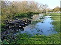
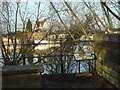
2
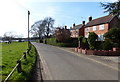
Evening at Gunthorpe
Looking across to the houses on the north bank of the River Trent, along Trentside.
Image: © Alan Murray-Rust
Taken: 6 Dec 2009
0.01 miles
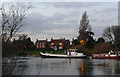
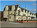
3
Gunthorpe riverside
These houses enjoy a prime view across the River Trent.
Image: © Alan Murray-Rust
Taken: 6 Jan 2008
0.03 miles
4
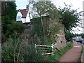
Remains of former Gunthorpe Toll Bridge
With former Toll House (white building, now a restaurant) above. For the remains of the bridge on the south bank see Image
Image: © Tim Heaton
Taken: 7 Sep 2008
0.03 miles
5
Migrating picnic tables, Gunthorpe
These look to have found their way here afloat on floodwater.
Image: © Alan Murray-Rust
Taken: 10 Nov 2019
0.03 miles
6
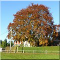
Alchemy at Gunthorpe - copper transmuting to gold
Copper beech in autumn colours.
Image: © Alan Murray-Rust
Taken: 10 Nov 2019
0.04 miles
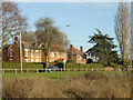
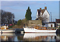
8
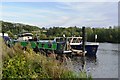
Moorings on the River Trent above Gunthorpe Lock
Image: © John M
Taken: 4 Sep 2016
0.04 miles
9
The old Gunthorpe Toll bridge
Looking from the south side to the abutment and toll cottage on the far bank. The information board states that the bridge was opened in 1875 following approval of a Parliamentary Bill (necessary to authorise the collection of tolls). As the project was relatively undersubscribed, only a relatively lightweight bridge could be built. limiting the traffic that could be carried. This was nevertheless an improvement on the previous ferry. With the growth of 20th Century traffic, the bridge was clearly inadequate. The County Council bought out the toll rights and built the present bridge which was opened by the Prince of Wales in 1927. It formed part of a brand new road linking the A46 with the A617, providing a route north for heavy traffic avoiding Loughborough and Nottingham.
Image: © Alan Murray-Rust
Taken: 6 Jan 2008
0.05 miles
10
River Trent at Gunthorpe
This is where the former toll bridge was situated. The abutment and toll cottage are on the far bank.
Image: © Alan Murray-Rust
Taken: 6 Jan 2008
0.05 miles