IMAGES TAKEN NEAR TO
Caythorpe Road, NOTTINGHAM, NG14 7EA
Introduction
This page details the photographs taken nearby to Caythorpe Road, NG14 7EA by members of the Geograph project.
The Geograph project started in 2005 with the aim of publishing, organising and preserving representative images for every square kilometre of Great Britain, Ireland and the Isle of Man.

There are currently over 7.5m images from over14,400 individuals and you can help contribute to the project by visiting https://www.geograph.org.uk
Image Map
Images are licensed for reuse under creativecommons.org/licenses/by-sa/2.0
Notes
- Clicking on the map will re-center to the selected point.
- The higher the marker number, the further away the image location is from the centre of the postcode.
Image Listing (70 Images Found)
Images are licensed for reuse under creativecommons.org/licenses/by-sa/2.0
Image
Details
Distance
1
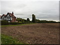
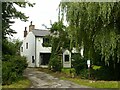
Mock Tudor semi at corner of fields
Stubble remains after harvesting.
Image: © Peter Barr
Taken: 12 Oct 2011
0.02 miles
2
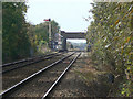
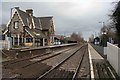
Railway at Lowdham
Looking towards to the station from the bridleway crossing to the east of the village.
Image: © Alan Murray-Rust
Taken: 16 Oct 2009
0.08 miles
3
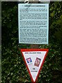
Caythorpe WW2 Village Trail, July 2021 ? No.1
Information relating to the cottage named Freiston. See also http://www.geograph.org.uk/photo/6901530
Image: © Alan Murray-Rust
Taken: 13 Jul 2021
0.09 miles
4
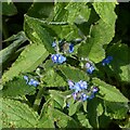
Germander Speedwell, Lowdham
Early spring flowers
Image: © Alan Murray-Rust
Taken: 6 Apr 2021
0.09 miles
5
Freiston, Caythorpe Road
A cottage dating back to the early 19th century, originally a small farmhouse with attached smallholding farm. See http://www.geograph.org.uk/photo/6901528
Image: © Alan Murray-Rust
Taken: 13 Jul 2021
0.09 miles
6
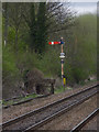
Lowdham Down Starting signal
This is the last remaining semaphore signal worked by Lowdham box and will disappear when the new signalling is installed.
Image: © Alan Murray-Rust
Taken: 6 Apr 2014
0.10 miles
7
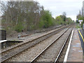
The east end of Lowdham Station
The goods siding has long since been separated from the running lines.
Image: © Alan Murray-Rust
Taken: 6 Apr 2014
0.12 miles
8
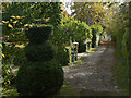
Bridleway near Lowdham
South of the railway, the bridleway provides access to a number of large detached houses.
Image: © Alan Murray-Rust
Taken: 16 Oct 2009
0.14 miles
9
Lowdham Station
From the road crossing looking towards Newark.
Image: © roger geach
Taken: 27 Nov 2008
0.15 miles
10
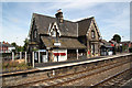
Lowdham Station
Mid-19th century station building, probably by T.C.Hine
Image: © Richard Croft
Taken: 10 Jul 2010
0.15 miles