IMAGES TAKEN NEAR TO
Lambley Road, NOTTINGHAM, NG14 7AY
Introduction
This page details the photographs taken nearby to Lambley Road, NG14 7AY by members of the Geograph project.
The Geograph project started in 2005 with the aim of publishing, organising and preserving representative images for every square kilometre of Great Britain, Ireland and the Isle of Man.

There are currently over 7.5m images from over14,400 individuals and you can help contribute to the project by visiting https://www.geograph.org.uk
Image Map
Images are licensed for reuse under creativecommons.org/licenses/by-sa/2.0
Notes
- Clicking on the map will re-center to the selected point.
- The higher the marker number, the further away the image location is from the centre of the postcode.
Image Listing (56 Images Found)
Images are licensed for reuse under creativecommons.org/licenses/by-sa/2.0
Image
Details
Distance
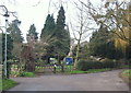
2
Lowdham, Notts.
This bridge on Church Lane carries traffic across Cocker Beck, passes the entrance gates to the parish church of St Mary the Virgin and then continues uphill for a further 200 metres until it reaches (the newer) graveyard extension situated at the conclusion of this cul-de-sac. This tributary arises in the Lambley Dumbles, passes through Lowdham and joins the River Trent at Gunthorpe.
Image: © David Hallam-Jones
Taken: 28 Feb 2014
0.07 miles
3
Lowdham, Notts.
Church Lane carries traffic across Cocker Beck (behind the photographer), passes the entrance gates to the parish church of St Mary the Virgin and then continues uphill for a further 200 metres until it reaches the local cemetery - an extension of the church's graveyard - that is situated at the conclusion of this cul-de-sac.
Image: © David Hallam-Jones
Taken: 28 Feb 2014
0.08 miles
4

Castle mound, Lowdham
Difficult to distinguish in a photograph, but the ground does rise from a moat to a plateau. Marked on the 1:25000 map, but apparently not listed as an ancient monument.
Image: © Alan Murray-Rust
Taken: 17 Oct 2008
0.08 miles
5
Footpath alongside the Cocker Beck
At this point the path curves between the stream and the outer earthwork of the old castle, which appears to have been a simple motte and bailey.
Image: © Alan Murray-Rust
Taken: 17 Oct 2008
0.08 miles
6
Church Lane
Narrow descent from Lowdham Cemetery
Image: © Richard Croft
Taken: 18 Oct 2007
0.09 miles
7
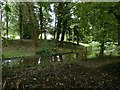
Medieval castle motte and moat, Lowdham
The motte was excavated in the late 1930s indicating the presence of a stone keep, possibly 14th century. The re-creation of a watered moat appears to be modern. The site is not scheduled.
Image: © Alan Murray-Rust
Taken: 13 Jun 2020
0.09 miles
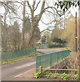
8
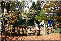
St.Mary's churchyard gates
Autumnal carpet of leaves and attractive gates to the church of St.Mary the Virgin at Lowdham
Image: © Richard Croft
Taken: 18 Oct 2007
0.10 miles
9
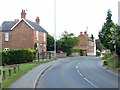
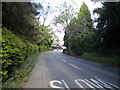
Lambley Lane, Lowdham
Part of the older part of the village on the western side of the Cocker Beck.
Image: © Alan Murray-Rust
Taken: 13 Jun 2020
0.10 miles
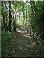
10

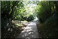
Footpath to the church
Lowdham Church is on the outskirts of the village, doubtless due to the location of the castle. This path is the most direct pedestrian access from the northern part of the village, which would account for it being so well engineered.
Image: © Alan Murray-Rust
Taken: 17 Oct 2008
0.10 miles