IMAGES TAKEN NEAR TO
Wiggett Street, NG14 6TP
Introduction
This page details the photographs taken nearby to Wiggett Street, NG14 6TP by members of the Geograph project.
The Geograph project started in 2005 with the aim of publishing, organising and preserving representative images for every square kilometre of Great Britain, Ireland and the Isle of Man.

There are currently over 7.5m images from over14,400 individuals and you can help contribute to the project by visiting https://www.geograph.org.uk
Image Map
Images are licensed for reuse under creativecommons.org/licenses/by-sa/2.0
Notes
- Clicking on the map will re-center to the selected point.
- The higher the marker number, the further away the image location is from the centre of the postcode.
Image Listing (31 Images Found)
Images are licensed for reuse under creativecommons.org/licenses/by-sa/2.0
Image
Details
Distance
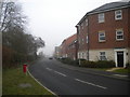
1
Flatts Lane
One of the old rural lanes out of the village, now being developed with housing.
Image: © Alan Murray-Rust
Taken: 14 Aug 2011
0.05 miles
2
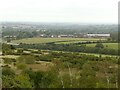
View from the Calverton spoil tip ? 3
Looking towards the valley of the Cocker Beck.
Early 21st century housing development on Flatt Lane can be seen beyond the open fields. The scrubland in the foreground is landscaped spoil tip, now owned by the Forestry Commission and designated as Open Access.
Image: © Alan Murray-Rust
Taken: 27 Sep 2020
0.07 miles
3
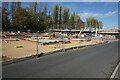
Willow Rise
New housing being built on the edge of Calverton, on the western side of Flatts Lane.
Image: © Bill Boaden
Taken: 15 Oct 2022
0.08 miles
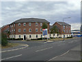
4
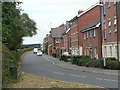
Flatts Lane, Calverton
Housing in Calverton has recently expanded northwards along the northern half of Flatts Lane (north of Park Road). The contrived variety and attempted Georgian styling seem typical of housing built in the last few years.
Image: © Richard Vince
Taken: 24 Nov 2012
0.09 miles
5
Cherry Orchards
Modern housing development on Park Road and Flatts Lane.
Image: © Alan Murray-Rust
Taken: 14 Aug 2011
0.09 miles
6
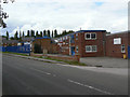
Industrial units on Park Road
Developed partly to offset the loss of employment when the colliery closed.
Image: © Alan Murray-Rust
Taken: 14 Aug 2011
0.09 miles
7
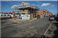
Willow Rise
New housing on the edge of Calverton on the western side of Flatts Lane.
Image: © Bill Boaden
Taken: 15 Oct 2022
0.10 miles
8
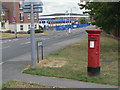
Park Road, Calverton postbox ref. NG14 375
E II R pillar box at the corner of Park Road and Flatts Lane.
Image: © Alan Murray-Rust
Taken: 14 Aug 2011
0.11 miles
9
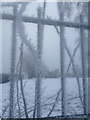
Calverton, Nottingham Sir John Sherbrooke boundary fence
Taken on my way to work at the school. It was a very cold morning and I couldn't resist this shot.
Image: © Andrew Barnes
Taken: 16 Jan 2013
0.12 miles
10
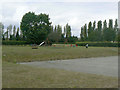
William Lee Memorial Park
An extensive recreation ground on the north side of the village named after the inventor of the knitting frame.
Image: © Alan Murray-Rust
Taken: 14 Aug 2011
0.12 miles