IMAGES TAKEN NEAR TO
Pheasant Way, NG14 6TA
Introduction
This page details the photographs taken nearby to Pheasant Way, NG14 6TA by members of the Geograph project.
The Geograph project started in 2005 with the aim of publishing, organising and preserving representative images for every square kilometre of Great Britain, Ireland and the Isle of Man.

There are currently over 7.5m images from over14,400 individuals and you can help contribute to the project by visiting https://www.geograph.org.uk
Image Map
Images are licensed for reuse under creativecommons.org/licenses/by-sa/2.0
Notes
- Clicking on the map will re-center to the selected point.
- The higher the marker number, the further away the image location is from the centre of the postcode.
Image Listing (35 Images Found)
Images are licensed for reuse under creativecommons.org/licenses/by-sa/2.0
Image
Details
Distance
1
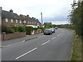
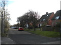
Park Road
The western leg of this road which forms the perimeter of the expansion of Calverton as a colliery village in the 1950s.
Image: © Alan Murray-Rust
Taken: 14 Aug 2011
0.10 miles
2
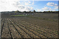
Stubble field near Calverton
A former crop of sweetcorn. Beyond the field is the north west expansion of housing in Calverton.
Image: © Bill Boaden
Taken: 15 Oct 2022
0.10 miles
3
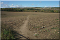
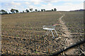
Footpath near Calverton
Moving away from the village. The high ground ahead was the tip of the former colliery. The last crop in this field was sweetcorn.
Image: © Bill Boaden
Taken: 15 Oct 2022
0.13 miles
4
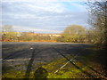
Disused car park off North Green, Calverton
Very close to the site of Calverton Colliery, which it presumably served.
Image: © Richard Vince
Taken: 2 Dec 2017
0.13 miles
5
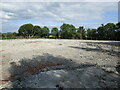
Vacant site off Hollinwood Lane
The site has been vacant for a good many years.
Image: © Jonathan Thacker
Taken: 17 Sep 2021
0.14 miles
6
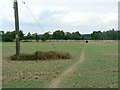
Field footpath near Calverton
Not a formal right of way, but clearly well used for all that.
Image: © Alan Murray-Rust
Taken: 14 Aug 2011
0.15 miles
7
Collyer Road
At the junction with Park Road, the end of the housing development. On the left is a small group of allotment gardens.
Image: © Alan Murray-Rust
Taken: 14 Aug 2011
0.15 miles
8
Forest Road
Part of the western block of development of Calverton as a colliery village in the 1950s.
Image: © Alan Murray-Rust
Taken: 14 Aug 2011
0.15 miles
9
North Green, Calverton
A residential cul de sac separate from the rest of the village, near the site of the colliery.
Image: © Richard Vince
Taken: 2 Dec 2017
0.16 miles
10
Footpath to Calverton
A new location for a supermarket trolley.
Image: © Bill Boaden
Taken: 15 Oct 2022
0.16 miles