IMAGES TAKEN NEAR TO
Sissons Lane, NG14 6SW
Introduction
This page details the photographs taken nearby to Sissons Lane, NG14 6SW by members of the Geograph project.
The Geograph project started in 2005 with the aim of publishing, organising and preserving representative images for every square kilometre of Great Britain, Ireland and the Isle of Man.

There are currently over 7.5m images from over14,400 individuals and you can help contribute to the project by visiting https://www.geograph.org.uk
Image Map
Images are licensed for reuse under creativecommons.org/licenses/by-sa/2.0
Notes
- Clicking on the map will re-center to the selected point.
- The higher the marker number, the further away the image location is from the centre of the postcode.
Image Listing (78 Images Found)
Images are licensed for reuse under creativecommons.org/licenses/by-sa/2.0
Image
Details
Distance
1
Calverton NG14, Notts.
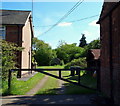
A good many Calverton-ites are unhappy about the fact that planning permission has been granted for a building company to construct 60+ houses on a plot of land beyond the greenhouse ahead. The new development will be constructed to the east of Dark Lane. The barn on the right, at 115 Main Street, is due to be demolished and an access road established to the green-field site in question.
Image: © David Hallam-Jones
Taken: 26 May 2013
0.08 miles
2
Woods Lane, Calverton
A public footpath. The house on the right is listed https://historicengland.org.uk/listing/the-list/list-entry/1227475
Image: © Jonathan Thacker
Taken: 17 Sep 2021
0.08 miles
3
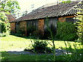
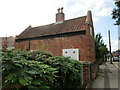
Calverton NG14, Notts.
The former forge at 135, Main Street, with the concrete circle on the grass that was used by the blacksmith to apply the thin iron bands to his wooden cart wheels.
Image: © David Hallam-Jones
Taken: 26 May 2013
0.08 miles
4
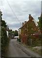
Woods Lane
A narrow field access lane off Main Street, with a fine display of Virginia Creeper.
Image: © Alan Murray-Rust
Taken: 14 Aug 2011
0.08 miles
5
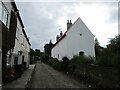
Museum Cottage, Calverton
Cottage, now a museum, dating from 1780 https://historicengland.org.uk/listing/the-list/list-entry/1235916
Image: © Jonathan Thacker
Taken: 17 Sep 2021
0.08 miles
6
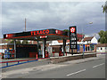
Manor Fuel Service Station
The village is large enough to support a major chain filling station.
Image: © Alan Murray-Rust
Taken: 14 Aug 2011
0.09 miles
7
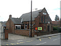
Baptist Church, Main Street
Originally the Primitive Methodist Church, as indicated in the stone band in the main gable. The original Baptist Chapel on The Nook http://www.geograph.org.uk/photo/2559190 is now the Baptist Church Hall.
Image: © Alan Murray-Rust
Taken: 14 Aug 2011
0.09 miles
8
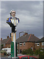
Admiral Rodney
A distinctive inn sign, it may bear little resemblance to the man himself.
Image: © Alan Murray-Rust
Taken: 14 Aug 2011
0.09 miles
9
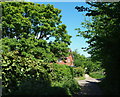
Calverton NG14, Notts.
Although difficult to tell because of the overgrown vegetation, this wall of vegetation on the left covers the remains of the boundary wall of a plot of land that was home to the Roe-ite chapel once used by John Roe, the founder of a local religious sect and his followers. The house at the crossroads of the tracks ahead is on Woods Lane, a road that is used by traffic coming from Main Road to the village cricket club ground, behind the photographer.
Image: © David Hallam-Jones
Taken: 26 May 2013
0.09 miles
10
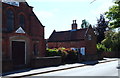
Calverton NG14, Notts.
The Calverton Museum, adjacent to the Baptist Church on Main Street, is housed in the four rooms of an 18th century Frame-knitter's (Stockinger's) cottage.
Image: © David Hallam-Jones
Taken: 26 May 2013
0.10 miles