IMAGES TAKEN NEAR TO
Bartley Gardens, NOTTINGHAM, NG14 6RG
Introduction
This page details the photographs taken nearby to Bartley Gardens, NG14 6RG by members of the Geograph project.
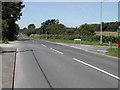
The Geograph project started in 2005 with the aim of publishing, organising and preserving representative images for every square kilometre of Great Britain, Ireland and the Isle of Man.

There are currently over 7.5m images from over14,400 individuals and you can help contribute to the project by visiting https://www.geograph.org.uk
Image Map
Images are licensed for reuse under creativecommons.org/licenses/by-sa/2.0
Notes
- Clicking on the map will re-center to the selected point.
- The higher the marker number, the further away the image location is from the centre of the postcode.
Image Listing (29 Images Found)
Images are licensed for reuse under creativecommons.org/licenses/by-sa/2.0
Image
Details
Distance
1
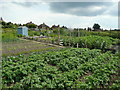
Allotments at Calverton
A fine crop of spuds in the foreground! View from Collyer Road.
Image: © Jonathan Billinger
Taken: 16 Jun 2008
0.06 miles
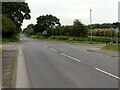
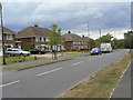
2
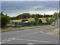
Collyer Road
At the junction with Park Road, the end of the housing development. On the left is a small group of allotment gardens.
Image: © Alan Murray-Rust
Taken: 14 Aug 2011
0.10 miles
3
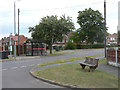
Collyer Road at Lee Road
The design of bench seat with the large baulk of timber at the back of the seat seems to be a specific local variant.
Image: © Alan Murray-Rust
Taken: 14 Aug 2011
0.13 miles
4
Hollinwood Lane, Calverton, Notts.
This is the start of the longer of two sections of Hollinwood Lane. Behind the photographer, and on the other side of a crossroads formed with Main Street, a shorter, asphalted cul-de-sac section of Hollinwood Lane. This continues in the opposite direction to serve a Recycling Centre (a.k.a "the local tip"), the Calverton Miners' Welfare Club and a small number of residential properties. Ahead however, this unmade section of the lane cuts through Ramsdale Park Golf Course and then it becomes a rural footpath.
Image: © David Hallam-Jones
Taken: 1 Oct 2015
0.14 miles
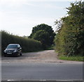
5
Junction of Hollinwood Lane and Main Street, Calverton
Straight ahead leads you to Patchings Farm Arts and Crafts Centre, right goes to the site of the old coal-mine and left goes up to a kennels and a golf course.
Image: © Tom Courtney
Taken: 8 Aug 2005
0.14 miles
6
Junction of Hollinwood Lane and Main Street, Calverton
Recreating this 'First' for the square https://www.geograph.org.uk/photo/34987
Image: © Alan Murray-Rust
Taken: 6 Jun 2023
0.14 miles
7
Hollinwood Lane, Calverton, Notts.
This housing estate at the junction of Main Street (bottom right hand corner) and Hollinwood Lane was completed in the September 2015. Behind the photographer Hollinwood Lane continues as an unmade track that cuts through Ramsdale Park Golf Course. Ahead however, i.e. past the street lamp, Hollinwood Lane becomes a dead end within a mile or so, serving to provide access (only) to a Gedling Council Recycling Centre (a.k.a "the local tip"), Calverton Miners' Welfare Club and a small cluster of older houses.
Image: © David Hallam-Jones
Taken: 1 Oct 2015
0.14 miles
8
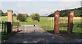
Hollinwood Lane, Calverton, Notts.
A set of gates leading towards an avenue of low trees or bushes in an otherwise unused field. This field has remained untouched for several years and there is no indication as to why the entrance was created. It sits a 50 metres or so along this cul-de-sac that provides access - on the photographer's right - to a Gedling Council Recycling Centre (a.k.a "a local tip"), to the Calverton Miners' Welfare Club, a new housing development and a small number of older houses.
Image: © David Hallam-Jones
Taken: 1 Oct 2015
0.14 miles
9
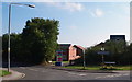
Collyer Road
See http://www.geograph.org.uk/photo/2558895 for a comment on this particular house design.
Image: © Alan Murray-Rust
Taken: 14 Aug 2011
0.15 miles
10
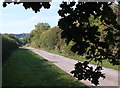
Hollinwood Lane, Calverton, Notts.
Hollinwood Lane is several miles long but it is bisected by Main Street, a principal route out of Calverton. Thus the lane is composed of this longer, unmade, section that bisects Ramsdale Park Golf Course (on either side of these hedges) and otherwise serves a private dwelling known as Hollinwood House and a second shorter, asphalted, cul-de-sac section that continues in the opposite direction to serve a Recycling Centre (a.k.a "the local tip"), the Calverton Miners' Welfare Club and a small number of residential properties.
Image: © David Hallam-Jones
Taken: 1 Oct 2015
0.15 miles