IMAGES TAKEN NEAR TO
Clover Fields, NOTTINGHAM, NG14 6PQ
Introduction
This page details the photographs taken nearby to Clover Fields, NG14 6PQ by members of the Geograph project.
The Geograph project started in 2005 with the aim of publishing, organising and preserving representative images for every square kilometre of Great Britain, Ireland and the Isle of Man.

There are currently over 7.5m images from over14,400 individuals and you can help contribute to the project by visiting https://www.geograph.org.uk
Image Map
Images are licensed for reuse under creativecommons.org/licenses/by-sa/2.0
Notes
- Clicking on the map will re-center to the selected point.
- The higher the marker number, the further away the image location is from the centre of the postcode.
Image Listing (12 Images Found)
Images are licensed for reuse under creativecommons.org/licenses/by-sa/2.0
Image
Details
Distance
1
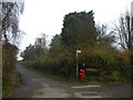
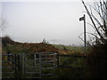
South end of Carrington Lane, Calverton
At this point, Carrington Lane (left) meets Crookdole Lane, which leads into Calverton proper to the west, but continues east from here as a track (right), which is shared for some distance by a public footpath, hence the sign.
Image: © Richard Vince
Taken: 24 Nov 2012
0.04 miles
2
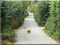
On the prowl
A ginger cat on Carrington Lane. This lane has retained its agricultural nature despite being on the edge of the urban development of the village.
Image: © Alan Murray-Rust
Taken: 14 Aug 2011
0.05 miles
3
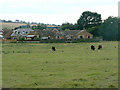
Pasture at Calverton
The houses mark the current limit of development of the village.
Image: © Alan Murray-Rust
Taken: 14 Aug 2011
0.07 miles
4
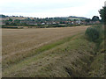
View towards Calverton
From Crookdale Lane
Image: © Alan Murray-Rust
Taken: 14 Aug 2011
0.10 miles
5
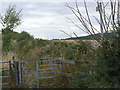
Footpath off Carrington Lane, Calverton
This footpath leads from the edge of Calverton to the A6097 some way south of Oxton, initially following a field boundary.
Image: © Richard Vince
Taken: 24 Nov 2012
0.14 miles
6
Footpath off Carrington Lane
This crosses fields to the neighbouring village of Oxton.
Image: © Alan Murray-Rust
Taken: 14 Aug 2011
0.14 miles
7
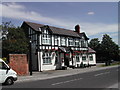
The Gleaners Public House
at the eastend of Calverton on the main road
Image: © Tom Courtney
Taken: 8 Aug 2005
0.18 miles
8
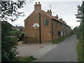
Carrington Cottages
Clearly originally intended for workers at the adjacent Carrington Farm, they have now been effectively incorporated into the main built-up development of Calverton, seen in the background. Older maps name them as Carrington Houses.
Image: © Alan Murray-Rust
Taken: 14 Aug 2011
0.18 miles
9
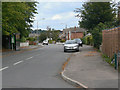
Park Road East
This is the main distributor road for the development of Calverton as a mining village in the 1950s and 60s, making a roughly semicircular sweep round the then northern periphery. This is its eastern end where it meets Bonner Lane.
Image: © Alan Murray-Rust
Taken: 14 Aug 2011
0.22 miles
10
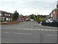
Broadfields
The name applies to the whole of this development to the north of Park Road East, with quite a network of roads sharing the same name. Apparently the name was intended to be Broomfields, as this shrub was prolific in the area before development; the actual name was the result of a typing error.
Image: © Alan Murray-Rust
Taken: 14 Aug 2011
0.23 miles