IMAGES TAKEN NEAR TO
Calverton, NOTTINGHAM, NG14 6PF
Introduction
This page details the photographs taken nearby to NG14 6PF by members of the Geograph project.
The Geograph project started in 2005 with the aim of publishing, organising and preserving representative images for every square kilometre of Great Britain, Ireland and the Isle of Man.

There are currently over 7.5m images from over14,400 individuals and you can help contribute to the project by visiting https://www.geograph.org.uk
Image Map
Images are licensed for reuse under creativecommons.org/licenses/by-sa/2.0
Notes
- Clicking on the map will re-center to the selected point.
- The higher the marker number, the further away the image location is from the centre of the postcode.
Image Listing (11 Images Found)
Images are licensed for reuse under creativecommons.org/licenses/by-sa/2.0
Image
Details
Distance
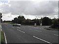
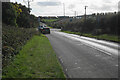
3
Oxton Road
Recreating this 'First' for the square https://www.geograph.org.uk/photo/36794 .
The junction was remodelled and traffic lights installed between 2015 and 2017.
Image: © Alan Murray-Rust
Taken: 6 Jun 2023
0.08 miles
4
Oxton Road
at the junction of Flats Lane/windbush Lane/Oxton Road on the edge of Calverton
Image: © Tom Courtney
Taken: 12 Aug 2005
0.08 miles
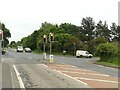
5
Crossroads near Calverton
Whinbush Lane meets the B6386. Some of the houses of Calverton are seen on the rise ahead.
Image: © Bill Boaden
Taken: 15 Oct 2022
0.08 miles
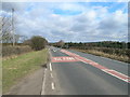
6
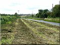
Mown verge
Whinbush Lane, looking towards Calverton. The mowings are largely bracken.
Image: © Alan Murray-Rust
Taken: 21 Jul 2020
0.10 miles
7
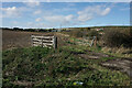
Field entrance near Calverton
This field is now on the edge of Calverton as new housing advances from the left.
Image: © Bill Boaden
Taken: 15 Oct 2022
0.12 miles
8
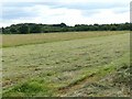
Partly mown field
Off Whinbush Lane, Calverton.
Image: © Alan Murray-Rust
Taken: 21 Jul 2020
0.14 miles
9
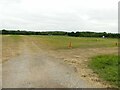
Site of antiquities, ancient and modern
The worn lanes in the grass show that this is the location of Calverton Car Boot, held every Sunday, where modern antiques may well be found.
Below the grass are more ancient remains, this being the site of two successive Roman encampments, the site being designated a Scheduled Monument. There are no surface earthworks, the camps having been identified through crop marks.
Image: © Alan Murray-Rust
Taken: 6 Jun 2023
0.14 miles
10
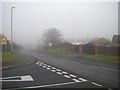
The northern fringe of Calverton
This is the junction of Flatts Lane (left) with Mansfield Lane, which effectively marks the northernmost point in Calverton village. A junction with the B6386 is less than a quarter of a mile away (hence the advance Give Way sign), but was hidden in the mist when this picture was taken.
Image: © Richard Vince
Taken: 24 Nov 2012
0.21 miles