IMAGES TAKEN NEAR TO
Foxwood Grove, NOTTINGHAM, NG14 6JF
Introduction
This page details the photographs taken nearby to Foxwood Grove, NG14 6JF by members of the Geograph project.
The Geograph project started in 2005 with the aim of publishing, organising and preserving representative images for every square kilometre of Great Britain, Ireland and the Isle of Man.

There are currently over 7.5m images from over14,400 individuals and you can help contribute to the project by visiting https://www.geograph.org.uk
Image Map
Images are licensed for reuse under creativecommons.org/licenses/by-sa/2.0
Notes
- Clicking on the map will re-center to the selected point.
- The higher the marker number, the further away the image location is from the centre of the postcode.
Image Listing (53 Images Found)
Images are licensed for reuse under creativecommons.org/licenses/by-sa/2.0
Image
Details
Distance
1
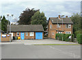
Calverton Police Station
At the back of St Wilfrid's Square. The house to the right was a police house, latterly used as Police offices.
Image: © Alan Murray-Rust
Taken: 14 Aug 2011
0.15 miles
2
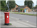
Calverton Post Office postbox (ref. NG14 350)
E II R pillar box, with the earlier 'Post Office' lettering, indicating that it is probably not a replacement for a built-in postbox, as is the case at many post offices. In the background is the local police station.
Image: © Alan Murray-Rust
Taken: 14 Aug 2011
0.15 miles
3
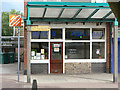
Calverton Post Office
Situated opposite the main shopping precinct.
Image: © Alan Murray-Rust
Taken: 14 Aug 2011
0.15 miles
4
Pete's Fish Bar
The real reason for taking this shot was to include the pre-Worboys style of sign for the Public Conveniences (still in existence, but currently closed) http://www.geograph.org.uk/photo/2559218.
Image: © Alan Murray-Rust
Taken: 14 Aug 2011
0.18 miles
5
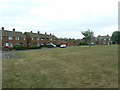
The green at Wood Grove
Part of the development of Calverton as a mining village in the 1950s. Originally this bit of open space looked out across agricultural land, behind the photographer.
Image: © Alan Murray-Rust
Taken: 14 Aug 2011
0.18 miles
6
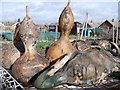
Weird Gourds
Left out to dry on an old bath tub at the village allotments.
Image: © Patrick Mackie
Taken: 11 Feb 2007
0.18 miles
7
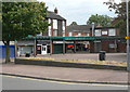
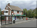
St Wilfrid's Square
The main shopping precinct in the village, developed when the village expanded as a colliery village. There is still a reasonable variety of shops, including a butcher, a baker and a small Sainsbury's branch, together with the usual clutch of takeaways.
Image: © Alan Murray-Rust
Taken: 14 Aug 2011
0.18 miles
8
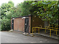
Public Inconveniences
Like so many, these toilets are currently out of use.
Update: In 2012: the Parish council took-over responsibility for this building and the conveniences are now once again in use.
Image: © Alan Murray-Rust
Taken: 14 Aug 2011
0.19 miles
9
Broadfields
The name applies to the whole of this development to the north of Park Road East, with quite a network of roads sharing the same name. Apparently the name was intended to be Broomfields, as this shrub was prolific in the area before development; the actual name was the result of a typing error.
Image: © Alan Murray-Rust
Taken: 14 Aug 2011
0.20 miles
10
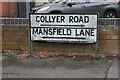
Signs at the junction of Collyer Road and Mansfield Lane
There is a pair of similar ones with short arrows opposite but I missed them.
Image: © David Howard
Taken: 16 Jul 2023
0.20 miles