IMAGES TAKEN NEAR TO
Crookdole Lane, NOTTINGHAM, NG14 6JA
Introduction
This page details the photographs taken nearby to Crookdole Lane, NG14 6JA by members of the Geograph project.
The Geograph project started in 2005 with the aim of publishing, organising and preserving representative images for every square kilometre of Great Britain, Ireland and the Isle of Man.

There are currently over 7.5m images from over14,400 individuals and you can help contribute to the project by visiting https://www.geograph.org.uk
Image Map
Images are licensed for reuse under creativecommons.org/licenses/by-sa/2.0
Notes
- Clicking on the map will re-center to the selected point.
- The higher the marker number, the further away the image location is from the centre of the postcode.
Image Listing (70 Images Found)
Images are licensed for reuse under creativecommons.org/licenses/by-sa/2.0
Image
Details
Distance
1
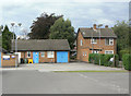
Calverton Police Station
At the back of St Wilfrid's Square. The house to the right was a police house, latterly used as Police offices.
Image: © Alan Murray-Rust
Taken: 14 Aug 2011
0.10 miles
2
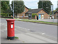
Calverton Post Office postbox (ref. NG14 350)
E II R pillar box, with the earlier 'Post Office' lettering, indicating that it is probably not a replacement for a built-in postbox, as is the case at many post offices. In the background is the local police station.
Image: © Alan Murray-Rust
Taken: 14 Aug 2011
0.11 miles
3
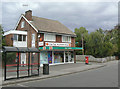
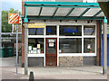
Calverton Post Office
Situated opposite the main shopping precinct.
Image: © Alan Murray-Rust
Taken: 14 Aug 2011
0.12 miles
4
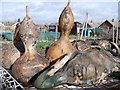
Weird Gourds
Left out to dry on an old bath tub at the village allotments.
Image: © Patrick Mackie
Taken: 11 Feb 2007
0.13 miles
5
Pete's Fish Bar
The real reason for taking this shot was to include the pre-Worboys style of sign for the Public Conveniences (still in existence, but currently closed) http://www.geograph.org.uk/photo/2559218.
Image: © Alan Murray-Rust
Taken: 14 Aug 2011
0.14 miles
6
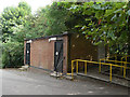
Public Inconveniences
Like so many, these toilets are currently out of use.
Update: In 2012: the Parish council took-over responsibility for this building and the conveniences are now once again in use.
Image: © Alan Murray-Rust
Taken: 14 Aug 2011
0.14 miles
7
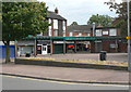
St Wilfrid's Square
The main shopping precinct in the village, developed when the village expanded as a colliery village. There is still a reasonable variety of shops, including a butcher, a baker and a small Sainsbury's branch, together with the usual clutch of takeaways.
Image: © Alan Murray-Rust
Taken: 14 Aug 2011
0.14 miles
8
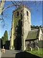
Church of St Wilfrid, Calverton
The west tower, rebuilt 1760-3 in Georgian ('James Gibbs rusticated') style, reusing the original Norman masonry. Listed Grade II*.
Image: © Alan Murray-Rust
Taken: 18 Jan 2023
0.15 miles
9
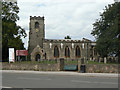
St Wilfrid's Church
Although dating from the late 13th/14th century, the nave and tower were largely rebuilt in 1763; the chancel was rebuilt in 1835 and the church again restored in 1881. The porch is of this period too. Note the use of spreaders in the form of a cross for the strengthening ties across the church. Listed Grade II*.
Image: © Alan Murray-Rust
Taken: 14 Aug 2011
0.15 miles
10
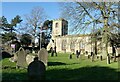
Church of St Wilfrid, Calverton
Although 13th century in origin, the external aspect is largely the result of major rebuilding, including the tower, in 1760-3. The Gothic windows were formed during the restoration of 1881, replacing round headed windows in style matching those of the tower. Listed Grade II*.
Image: © Alan Murray-Rust
Taken: 18 Jan 2023
0.15 miles