IMAGES TAKEN NEAR TO
Bonner Lane, NOTTINGHAM, NG14 6FS
Introduction
This page details the photographs taken nearby to Bonner Lane, NG14 6FS by members of the Geograph project.
The Geograph project started in 2005 with the aim of publishing, organising and preserving representative images for every square kilometre of Great Britain, Ireland and the Isle of Man.

There are currently over 7.5m images from over14,400 individuals and you can help contribute to the project by visiting https://www.geograph.org.uk
Image Map
Images are licensed for reuse under creativecommons.org/licenses/by-sa/2.0
Notes
- Clicking on the map will re-center to the selected point.
- The higher the marker number, the further away the image location is from the centre of the postcode.
Image Listing (73 Images Found)
Images are licensed for reuse under creativecommons.org/licenses/by-sa/2.0
Image
Details
Distance
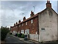
1
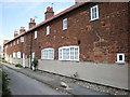
Windle Square, Calverton
A set of renovated framework knitters cottages. Note the long windows essential for framework knitters to work at their frames using natural light. The 'Lee handframe' was reputed to have been invented by the Rev. William Lee, the curate of Calverton.
Image: © Karen Chantrey Wood
Taken: 13 Jun 2009
0.02 miles
2
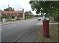
Main Street Calverton postbox (ref. NG14 23)
E II R pillar box at the corner of Bonner Lane and Bonner Hill, where Main Street ends. The postbox on Main Street nearer the centre of the village is called Mews Lane http://www.geograph.org.uk/photo/2559143.
The cottages to the left are Windles Square http://www.geograph.org.uk/photo/2558512.
Image: © Alan Murray-Rust
Taken: 14 Aug 2011
0.03 miles
3
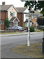
Traditional fingerpost
At the junction of Main Street and Bonner Hill.
Image: © Alan Murray-Rust
Taken: 14 Aug 2011
0.03 miles
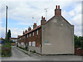
4
Windles Square, west range
A row of framework knitters cottages, built in 1834, restored in 1974. The large windows show that in these cottages the workshops were on the ground floor, although many other knitters' cottages have upper floor workshops.
The stocking frame was invented by William Lee of Calverton in 1589, although its use in Calverton did not take hold until the early 19th century. The cottages are Listed Grade II.
Image: © Alan Murray-Rust
Taken: 18 Jan 2023
0.03 miles
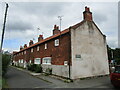
5
Windles Square in Calverton
Restored row of framework knitters cottages dating from 1834. A commemorative plaque is attached to the gable end.
Image: © Jonathan Clitheroe
Taken: 9 Sep 2024
0.03 miles
6
Windles Square, Calverton
Former framework knitters' cottages dating from 1834 https://historicengland.org.uk/listing/the-list/list-entry/1235886
Image: © Jonathan Thacker
Taken: 17 Sep 2021
0.03 miles
7
Calverton NG14, Notts.
One wing of the Windles Square cottages. These were built in 1834 and named after their builder, Windles Smith. Unlike most other framework knitter's (or "stockinger's") cottages these have their larger windows on the ground floor in order to be able to benefit from the maximum amount of prevailing sunlight. Originally the "Square" consisted of a complex of three rows but the third was demolished in the 1960s. The complex was renovated by the Nottingham Buildings Preservation Trust in 1974. This service road joins the main road, i.e. Bonner Lane, in the distance.
Image: © David Hallam-Jones
Taken: 26 May 2013
0.03 miles
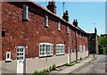
8
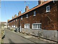
Windles Square
A group of terraced cottages built for framework knitters, of which the western and part of the northern rows still survive. This is the rear face of the western row and shows to advantage the large windows to provide light for the knitters. Unusually these are on the ground floor rather than the more traditional attic location; this is a feature of a number of buildings in Calverton. The cottages were built in 1834 and renovated in 1974, commemorated by the plaque on the side of the building. Listed Grade II.
Image: © Alan Murray-Rust
Taken: 14 Aug 2011
0.03 miles
9
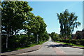
Calverton NG14, Notts.
Bonner Hill from the point on this T junction where Main Street becomes Bonner Lane. Further along this road Bonner Hill becomes Foxwood Lane, a road that in turn leads to the village of Woodborough.
Image: © David Hallam-Jones
Taken: 26 May 2013
0.04 miles
10
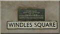
Windle Square ? commemorative plaque
See https://www.geograph.org.uk/photo/7385968 for location.
Image: © Alan Murray-Rust
Taken: 18 Jan 2023
0.04 miles