IMAGES TAKEN NEAR TO
Main Street, NOTTINGHAM, NG14 6FE
Introduction
This page details the photographs taken nearby to Main Street, NG14 6FE by members of the Geograph project.
The Geograph project started in 2005 with the aim of publishing, organising and preserving representative images for every square kilometre of Great Britain, Ireland and the Isle of Man.

There are currently over 7.5m images from over14,400 individuals and you can help contribute to the project by visiting https://www.geograph.org.uk
Image Map
Images are licensed for reuse under creativecommons.org/licenses/by-sa/2.0
Notes
- Clicking on the map will re-center to the selected point.
- The higher the marker number, the further away the image location is from the centre of the postcode.
Image Listing (49 Images Found)
Images are licensed for reuse under creativecommons.org/licenses/by-sa/2.0
Image
Details
Distance
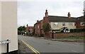
1
Calverton NG14, Notts.
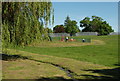
A view over the boundary wall of James Seely Park on Main Street. This recreation ground is named after Major James Seely, President of the Cricket Club, whose premises are at the top of this slope.
Image: © David Hallam-Jones
Taken: 26 May 2013
0.01 miles
2
James Seely Playing Field
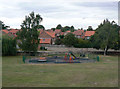
Looking across to Old Hall Close, a modern housing development on the site of the Old Hall (former Vicarage). The development is not within the boundary of the Conservation Area, but has made an attempt to integrate with the use of traditional brickwork and pantiles.
Image: © Alan Murray-Rust
Taken: 14 Aug 2011
0.02 miles
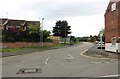
3
Main Street, Calverton
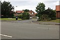
Looking towards Old Hall Close
Image: © David Howard
Taken: 16 Jul 2023
0.03 miles
4
Houses on Main Street
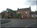
Part of the Calverton Conservation area, but not listed, or deemed to be of particular local interest.
Image: © Alan Murray-Rust
Taken: 14 Aug 2011
0.04 miles
6
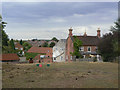
145 Main Street
The barns beyond the house indicate that it would originally have been a farm, although it is not named on earlier mapping.
Image: © Alan Murray-Rust
Taken: 14 Aug 2011
0.06 miles
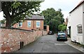
8
George's Lane, Calverton
From Main Street
Image: © David Howard
Taken: 16 Jul 2023
0.07 miles
9
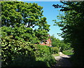
Calverton NG14, Notts.
Although difficult to tell because of the overgrown vegetation, this wall of vegetation on the left covers the remains of the boundary wall of a plot of land that was home to the Roe-ite chapel once used by John Roe, the founder of a local religious sect and his followers. The house at the crossroads of the tracks ahead is on Woods Lane, a road that is used by traffic coming from Main Road to the village cricket club ground, behind the photographer.
Image: © David Hallam-Jones
Taken: 26 May 2013
0.07 miles
10
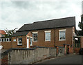
Calverton Village Hall
I have been unable to discover the original use of this building. There is a stone in the right hand gable displaying an open book inscribed 'Bible', so it may well have been a Sunday School.
Image: © Alan Murray-Rust
Taken: 14 Aug 2011
0.07 miles